You are here: Home > Network List > TA - USArray Transportable Network (new EarthScope stations) Stations List
> Station 115A Sonoran Desert, Stanfield, AZ, USA > Earthquake Result Viewer
115A Sonoran Desert, Stanfield, AZ, USA - Earthquake Result Viewer
| Earthquake location: |
Santiago Del Estero Prov., Arg. |
| Earthquake latitude/longitude: |
-26.0/-63.2 |
| Earthquake time(UTC): |
2006/11/13 (317) 01:26:34 GMT |
| Earthquake Depth: |
552 km |
| Earthquake Magnitude: |
6.3 MB, 6.8 MW, 6.8 MW |
| Earthquake Catalog/Contributor: |
WHDF/NEIC |
|
| Network: |
TA USArray Transportable Network (new EarthScope stations) |
| Station: |
115A Sonoran Desert, Stanfield, AZ, USA |
| Lat/Lon: |
32.70 N/112.23 W |
| Elevation: |
606 m |
|
| Distance: |
74.8 deg |
| Az: |
318.732 deg |
| Baz: |
135.269 deg |
| Ray Param: |
0.050350163 |
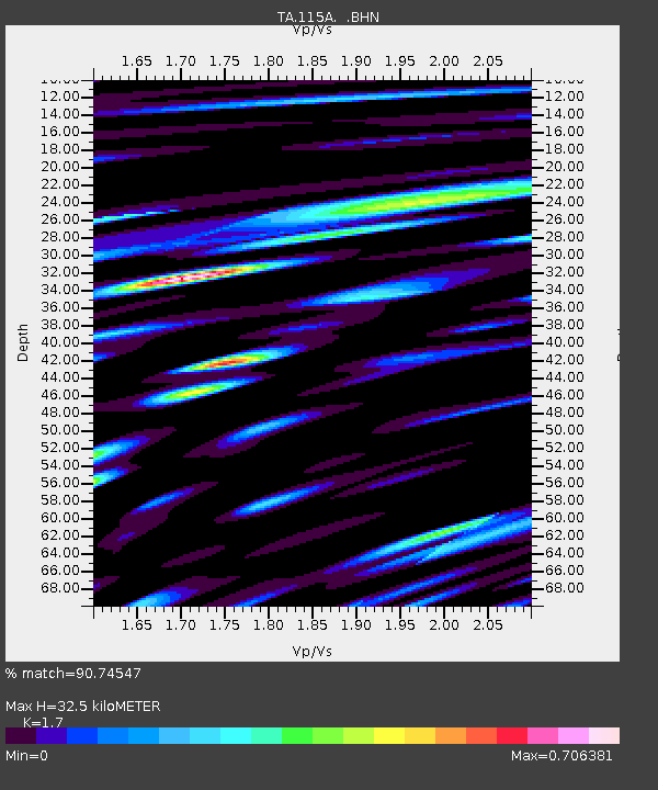
| Estimated Moho Depth: |
32.5 km |
| Estimated Crust Vp/Vs: |
1.70 |
| Assumed Crust Vp: |
6.264 km/s |
| Estimated Crust Vs: |
3.684 km/s |
| Estimated Crust Poisson's Ratio: |
0.24 |
|
| Radial Match: |
90.74547 % |
| Radial Bump: |
400 |
| Transverse Match: |
84.445816 % |
| Transverse Bump: |
400 |
| SOD ConfigId: |
2564 |
| Insert Time: |
2010-03-06 06:35:39.860 +0000 |
| GWidth: |
2.5 |
| Max Bumps: |
400 |
| Tol: |
0.001 |
|

Signal To Noise
| Channel | StoN | STA | LTA |
| TA:115A: :BHN:20061113T01:36:47.025012Z | 1.8753067 | 2.2908378E-7 | 1.2215803E-7 |
| TA:115A: :BHE:20061113T01:36:47.025012Z | 0.9408596 | 2.4602818E-7 | 2.6149297E-7 |
| TA:115A: :BHZ:20061113T01:36:47.025012Z | 2.7816172 | 7.5176547E-7 | 2.7026203E-7 |
| Arrivals |
| Ps | 3.7 SECOND |
| PpPs | 14 SECOND |
| PsPs/PpSs | 17 SECOND |


