You are here: Home > Network List > TA - USArray Transportable Network (new EarthScope stations) Stations List
> Station 115A Sonoran Desert, Stanfield, AZ, USA > Earthquake Result Viewer
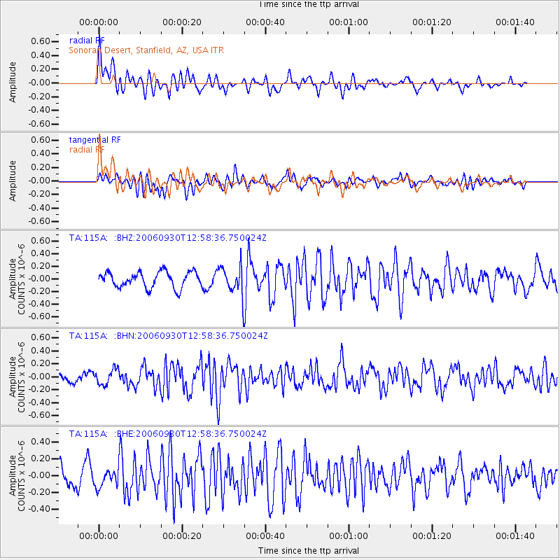
115A Sonoran Desert, Stanfield, AZ, USA - Earthquake Result Viewer
| Earthquake location: |
Central Mid-Atlantic Ridge |
| Earthquake latitude/longitude: |
7.3/-34.7 |
| Earthquake time(UTC): |
2006/09/30 (273) 12:47:22 GMT |
| Earthquake Depth: |
10 km |
| Earthquake Magnitude: |
5.6 MB, 5.0 MS, 5.5 MW |
| Earthquake Catalog/Contributor: |
WHDF/NEIC |
|
| Network: |
TA USArray Transportable Network (new EarthScope stations) |
| Station: |
115A Sonoran Desert, Stanfield, AZ, USA |
| Lat/Lon: |
32.70 N/112.23 W |
| Elevation: |
606 m |
|
| Distance: |
75.7 deg |
| Az: |
301.801 deg |
| Baz: |
90.51 deg |
| Ray Param: |
0.05152226 |
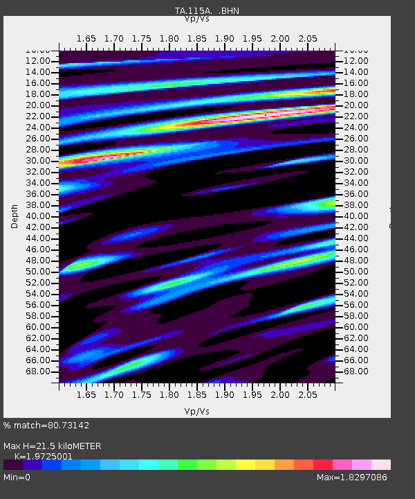
| Estimated Moho Depth: |
21.5 km |
| Estimated Crust Vp/Vs: |
1.97 |
| Assumed Crust Vp: |
6.264 km/s |
| Estimated Crust Vs: |
3.175 km/s |
| Estimated Crust Poisson's Ratio: |
0.33 |
|
| Radial Match: |
80.73142 % |
| Radial Bump: |
400 |
| Transverse Match: |
84.69968 % |
| Transverse Bump: |
400 |
| SOD ConfigId: |
2665 |
| Insert Time: |
2010-03-06 06:36:03.892 +0000 |
| GWidth: |
2.5 |
| Max Bumps: |
400 |
| Tol: |
0.001 |
|
Signal To Noise
| Channel | StoN | STA | LTA |
| TA:115A: :BHN:20060930T12:58:36.750024Z | 1.5687762 | 1.2242042E-7 | 7.803562E-8 |
| TA:115A: :BHE:20060930T12:58:36.750024Z | 0.79416853 | 1.06285974E-7 | 1.3383303E-7 |
| TA:115A: :BHZ:20060930T12:58:36.750024Z | 1.9202719 | 2.3753336E-7 | 1.2369777E-7 |
| Arrivals |
| Ps | 3.4 SECOND |
| PpPs | 9.9 SECOND |
| PsPs/PpSs | 13 SECOND |


