You are here: Home > Network List > AV - Alaska Volcano Observatory Stations List
> Station AMKA Regional Station, Amchitka Island, Alaska > Earthquake Result Viewer
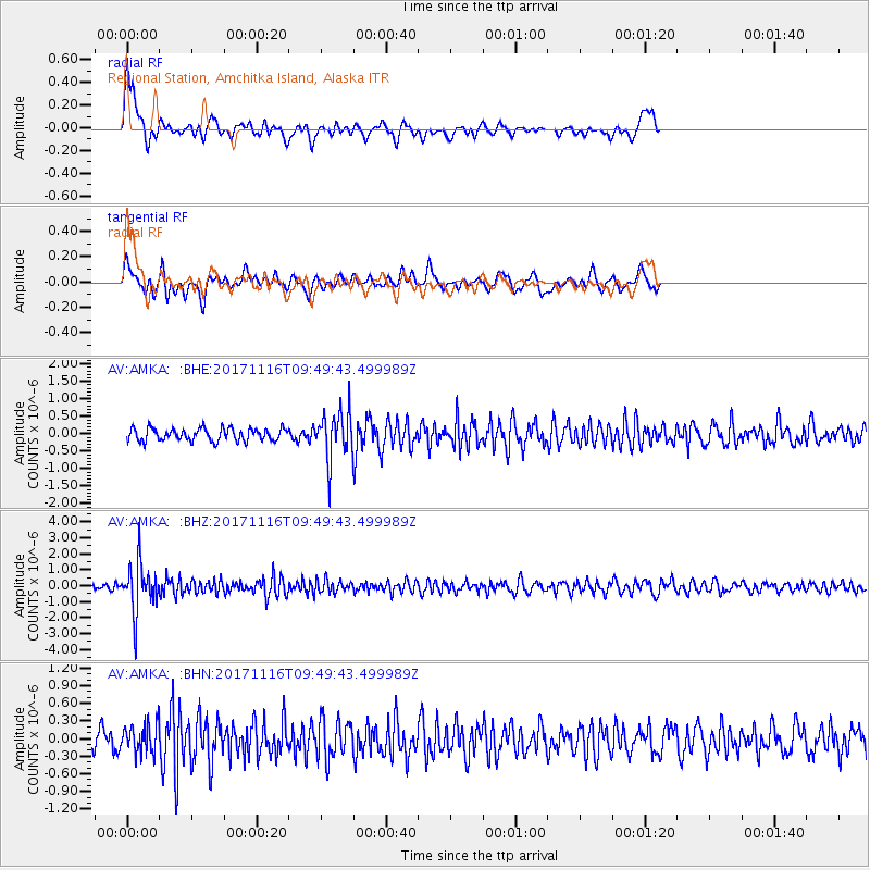
AMKA Regional Station, Amchitka Island, Alaska - Earthquake Result Viewer
*The percent match for this event was below the threshold and hence no stack was calculated.
| Earthquake location: |
Southeast Of Honshu, Japan |
| Earthquake latitude/longitude: |
32.2/140.5 |
| Earthquake time(UTC): |
2017/11/16 (320) 09:43:35 GMT |
| Earthquake Depth: |
71 km |
| Earthquake Magnitude: |
5.8 Mww |
| Earthquake Catalog/Contributor: |
NEIC PDE/us |
|
| Network: |
AV Alaska Volcano Observatory |
| Station: |
AMKA Regional Station, Amchitka Island, Alaska |
| Lat/Lon: |
51.38 N/179.30 E |
| Elevation: |
116 m |
|
| Distance: |
34.2 deg |
| Az: |
44.328 deg |
| Baz: |
250.975 deg |
| Ray Param: |
$rayparam |
*The percent match for this event was below the threshold and hence was not used in the summary stack. |
|
| Radial Match: |
60.558178 % |
| Radial Bump: |
400 |
| Transverse Match: |
52.257404 % |
| Transverse Bump: |
351 |
| SOD ConfigId: |
13570011 |
| Insert Time: |
2019-04-29 05:56:37.178 +0000 |
| GWidth: |
2.5 |
| Max Bumps: |
400 |
| Tol: |
0.001 |
|
Signal To Noise
| Channel | StoN | STA | LTA |
| AV:AMKA: :BHZ:20171116T09:49:43.499989Z | 7.544983 | 1.5157243E-6 | 2.0089168E-7 |
| AV:AMKA: :BHN:20171116T09:49:43.499989Z | 1.2781698 | 2.4501693E-7 | 1.9169359E-7 |
| AV:AMKA: :BHE:20171116T09:49:43.499989Z | 3.8314242 | 6.8871117E-7 | 1.797533E-7 |
| Arrivals |
| Ps | |
| PpPs | |
| PsPs/PpSs | |


