You are here: Home > Network List > CI - Caltech Regional Seismic Network Stations List
> Station TIN Tinemaha, Big Pine, CA, USA > Earthquake Result Viewer
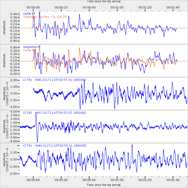
TIN Tinemaha, Big Pine, CA, USA - Earthquake Result Viewer
*The percent match for this event was below the threshold and hence no stack was calculated.
| Earthquake location: |
Southeast Of Honshu, Japan |
| Earthquake latitude/longitude: |
32.2/140.5 |
| Earthquake time(UTC): |
2017/11/16 (320) 09:43:35 GMT |
| Earthquake Depth: |
71 km |
| Earthquake Magnitude: |
5.8 Mww |
| Earthquake Catalog/Contributor: |
NEIC PDE/us |
|
| Network: |
CI Caltech Regional Seismic Network |
| Station: |
TIN Tinemaha, Big Pine, CA, USA |
| Lat/Lon: |
37.05 N/118.23 W |
| Elevation: |
1197 m |
|
| Distance: |
79.3 deg |
| Az: |
53.001 deg |
| Baz: |
302.168 deg |
| Ray Param: |
$rayparam |
*The percent match for this event was below the threshold and hence was not used in the summary stack. |
|
| Radial Match: |
71.76191 % |
| Radial Bump: |
400 |
| Transverse Match: |
56.85847 % |
| Transverse Bump: |
400 |
| SOD ConfigId: |
13570011 |
| Insert Time: |
2019-04-29 05:58:10.828 +0000 |
| GWidth: |
2.5 |
| Max Bumps: |
400 |
| Tol: |
0.001 |
|
Signal To Noise
| Channel | StoN | STA | LTA |
| CI:TIN: :HHZ:20171116T09:55:02.188008Z | 11.224423 | 1.7281739E-6 | 1.5396549E-7 |
| CI:TIN: :HHN:20171116T09:55:02.188008Z | 1.2166922 | 6.3676123E-7 | 5.233544E-7 |
| CI:TIN: :HHE:20171116T09:55:02.188008Z | 1.9626485 | 8.200897E-7 | 4.178485E-7 |
| Arrivals |
| Ps | |
| PpPs | |
| PsPs/PpSs | |


