You are here: Home > Network List > CI - Caltech Regional Seismic Network Stations List
> Station TUQ Turquiose Mountain, Baker, CA, USA > Earthquake Result Viewer
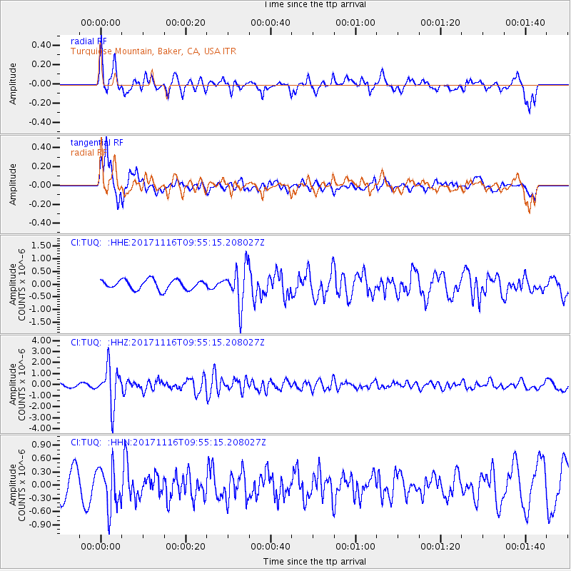
TUQ Turquiose Mountain, Baker, CA, USA - Earthquake Result Viewer
*The percent match for this event was below the threshold and hence no stack was calculated.
| Earthquake location: |
Southeast Of Honshu, Japan |
| Earthquake latitude/longitude: |
32.2/140.5 |
| Earthquake time(UTC): |
2017/11/16 (320) 09:43:35 GMT |
| Earthquake Depth: |
71 km |
| Earthquake Magnitude: |
5.8 Mww |
| Earthquake Catalog/Contributor: |
NEIC PDE/us |
|
| Network: |
CI Caltech Regional Seismic Network |
| Station: |
TUQ Turquiose Mountain, Baker, CA, USA |
| Lat/Lon: |
35.44 N/115.92 W |
| Elevation: |
1350 m |
|
| Distance: |
81.7 deg |
| Az: |
53.35 deg |
| Baz: |
303.583 deg |
| Ray Param: |
$rayparam |
*The percent match for this event was below the threshold and hence was not used in the summary stack. |
|
| Radial Match: |
68.089745 % |
| Radial Bump: |
400 |
| Transverse Match: |
76.08351 % |
| Transverse Bump: |
400 |
| SOD ConfigId: |
13570011 |
| Insert Time: |
2019-04-29 05:58:11.288 +0000 |
| GWidth: |
2.5 |
| Max Bumps: |
400 |
| Tol: |
0.001 |
|
Signal To Noise
| Channel | StoN | STA | LTA |
| CI:TUQ: :HHZ:20171116T09:55:15.208027Z | 6.150775 | 1.7674718E-6 | 2.8735755E-7 |
| CI:TUQ: :HHN:20171116T09:55:15.208027Z | 1.7676703 | 4.860921E-7 | 2.7499027E-7 |
| CI:TUQ: :HHE:20171116T09:55:15.208027Z | 4.0518026 | 7.7824234E-7 | 1.920731E-7 |
| Arrivals |
| Ps | |
| PpPs | |
| PsPs/PpSs | |


