You are here: Home > Network List > CN - Canadian National Seismograph Network Stations List
> Station INK INUVIK, NT > Earthquake Result Viewer
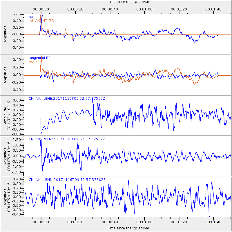
INK INUVIK, NT - Earthquake Result Viewer
*The percent match for this event was below the threshold and hence no stack was calculated.
| Earthquake location: |
Southeast Of Honshu, Japan |
| Earthquake latitude/longitude: |
32.2/140.5 |
| Earthquake time(UTC): |
2017/11/16 (320) 09:43:35 GMT |
| Earthquake Depth: |
71 km |
| Earthquake Magnitude: |
5.8 Mww |
| Earthquake Catalog/Contributor: |
NEIC PDE/us |
|
| Network: |
CN Canadian National Seismograph Network |
| Station: |
INK INUVIK, NT |
| Lat/Lon: |
68.31 N/133.53 W |
| Elevation: |
44 m |
|
| Distance: |
59.0 deg |
| Az: |
25.625 deg |
| Baz: |
279.477 deg |
| Ray Param: |
$rayparam |
*The percent match for this event was below the threshold and hence was not used in the summary stack. |
|
| Radial Match: |
50.951355 % |
| Radial Bump: |
400 |
| Transverse Match: |
61.361916 % |
| Transverse Bump: |
400 |
| SOD ConfigId: |
13570011 |
| Insert Time: |
2019-04-29 05:58:26.809 +0000 |
| GWidth: |
2.5 |
| Max Bumps: |
400 |
| Tol: |
0.001 |
|
Signal To Noise
| Channel | StoN | STA | LTA |
| CN:INK: :BHZ:20171116T09:52:57.37502Z | 4.1476135 | 7.198002E-7 | 1.7354562E-7 |
| CN:INK: :BHN:20171116T09:52:57.37502Z | 1.1593118 | 9.8950274E-8 | 8.5352596E-8 |
| CN:INK: :BHE:20171116T09:52:57.37502Z | 1.552994 | 3.951794E-7 | 2.5446292E-7 |
| Arrivals |
| Ps | |
| PpPs | |
| PsPs/PpSs | |


