You are here: Home > Network List > CI - Caltech Regional Seismic Network Stations List
> Station GRA Grapevine Ranger Station, Death Valley, CA, USA > Earthquake Result Viewer
GRA Grapevine Ranger Station, Death Valley, CA, USA - Earthquake Result Viewer
| Earthquake location: |
Near East Coast Of Kamchatka |
| Earthquake latitude/longitude: |
51.1/157.5 |
| Earthquake time(UTC): |
2006/08/24 (236) 21:50:36 GMT |
| Earthquake Depth: |
43 km |
| Earthquake Magnitude: |
5.9 MB, 6.2 MS, 6.5 MW, 6.5 MW |
| Earthquake Catalog/Contributor: |
WHDF/NEIC |
|
| Network: |
CI Caltech Regional Seismic Network |
| Station: |
GRA Grapevine Ranger Station, Death Valley, CA, USA |
| Lat/Lon: |
37.00 N/117.37 W |
| Elevation: |
689 m |
|
| Distance: |
59.4 deg |
| Az: |
67.869 deg |
| Baz: |
313.217 deg |
| Ray Param: |
0.06209279 |
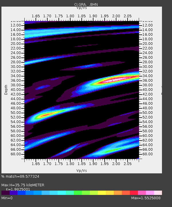
| Estimated Moho Depth: |
35.75 km |
| Estimated Crust Vp/Vs: |
1.98 |
| Assumed Crust Vp: |
6.279 km/s |
| Estimated Crust Vs: |
3.167 km/s |
| Estimated Crust Poisson's Ratio: |
0.33 |
|
| Radial Match: |
89.577324 % |
| Radial Bump: |
400 |
| Transverse Match: |
76.44937 % |
| Transverse Bump: |
400 |
| SOD ConfigId: |
2665 |
| Insert Time: |
2010-02-26 01:38:33.503 +0000 |
| GWidth: |
2.5 |
| Max Bumps: |
400 |
| Tol: |
0.001 |
|

Signal To Noise
| Channel | StoN | STA | LTA |
| CI:GRA: :BHN:20060824T22:00:04.347021Z | 3.7214732 | 6.713049E-7 | 1.8038688E-7 |
| CI:GRA: :BHE:20060824T22:00:04.347021Z | 7.770285 | 1.2430316E-6 | 1.5997246E-7 |
| CI:GRA: :BHZ:20060824T22:00:04.347021Z | 27.899515 | 3.1537177E-6 | 1.13038446E-7 |
| Arrivals |
| Ps | 5.8 SECOND |
| PpPs | 16 SECOND |
| PsPs/PpSs | 22 SECOND |


