You are here: Home > Network List > RV - Regional Alberta Seismic Observatory for Earthquake Studies Network Stations List
> Station YELLA Yellowhead Lookout Tower, AB > Earthquake Result Viewer
YELLA Yellowhead Lookout Tower, AB - Earthquake Result Viewer
| Earthquake location: |
Southeast Of Honshu, Japan |
| Earthquake latitude/longitude: |
32.2/140.5 |
| Earthquake time(UTC): |
2017/11/16 (320) 09:43:35 GMT |
| Earthquake Depth: |
71 km |
| Earthquake Magnitude: |
5.8 Mww |
| Earthquake Catalog/Contributor: |
NEIC PDE/us |
|
| Network: |
RV Regional Alberta Seismic Observatory for Earthquake Studies Network |
| Station: |
YELLA Yellowhead Lookout Tower, AB |
| Lat/Lon: |
53.24 N/117.14 W |
| Elevation: |
1478 m |
|
| Distance: |
71.6 deg |
| Az: |
38.225 deg |
| Baz: |
299.208 deg |
| Ray Param: |
0.054032143 |
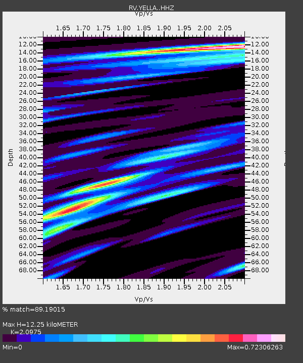
| Estimated Moho Depth: |
12.25 km |
| Estimated Crust Vp/Vs: |
2.10 |
| Assumed Crust Vp: |
6.142 km/s |
| Estimated Crust Vs: |
2.928 km/s |
| Estimated Crust Poisson's Ratio: |
0.35 |
|
| Radial Match: |
89.19015 % |
| Radial Bump: |
399 |
| Transverse Match: |
70.26101 % |
| Transverse Bump: |
400 |
| SOD ConfigId: |
13570011 |
| Insert Time: |
2019-04-29 06:02:57.896 +0000 |
| GWidth: |
2.5 |
| Max Bumps: |
400 |
| Tol: |
0.001 |
|

Signal To Noise
| Channel | StoN | STA | LTA |
| RV:YELLA: :HHZ:20171116T09:54:18.599995Z | 6.867613 | 1.389238E-6 | 2.0228835E-7 |
| RV:YELLA: :HHN:20171116T09:54:18.599995Z | 3.0034246 | 7.2151266E-7 | 2.4022998E-7 |
| RV:YELLA: :HHE:20171116T09:54:18.599995Z | 2.6970177 | 8.088256E-7 | 2.9989627E-7 |
| Arrivals |
| Ps | 2.2 SECOND |
| PpPs | 6.0 SECOND |
| PsPs/PpSs | 8.3 SECOND |


