You are here: Home > Network List > TA - USArray Transportable Network (new EarthScope stations) Stations List
> Station C16K Lisburne Hills, AK, USA > Earthquake Result Viewer
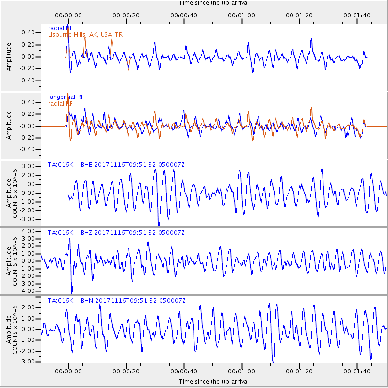
C16K Lisburne Hills, AK, USA - Earthquake Result Viewer
*The percent match for this event was below the threshold and hence no stack was calculated.
| Earthquake location: |
Southeast Of Honshu, Japan |
| Earthquake latitude/longitude: |
32.2/140.5 |
| Earthquake time(UTC): |
2017/11/16 (320) 09:43:35 GMT |
| Earthquake Depth: |
71 km |
| Earthquake Magnitude: |
5.8 Mww |
| Earthquake Catalog/Contributor: |
NEIC PDE/us |
|
| Network: |
TA USArray Transportable Network (new EarthScope stations) |
| Station: |
C16K Lisburne Hills, AK, USA |
| Lat/Lon: |
68.27 N/165.34 W |
| Elevation: |
102 m |
|
| Distance: |
47.4 deg |
| Az: |
24.196 deg |
| Baz: |
248.978 deg |
| Ray Param: |
$rayparam |
*The percent match for this event was below the threshold and hence was not used in the summary stack. |
|
| Radial Match: |
55.181602 % |
| Radial Bump: |
400 |
| Transverse Match: |
50.262794 % |
| Transverse Bump: |
392 |
| SOD ConfigId: |
13570011 |
| Insert Time: |
2019-04-29 06:03:19.051 +0000 |
| GWidth: |
2.5 |
| Max Bumps: |
400 |
| Tol: |
0.001 |
|
Signal To Noise
| Channel | StoN | STA | LTA |
| TA:C16K: :BHZ:20171116T09:51:32.050007Z | 2.3648574 | 1.7694526E-6 | 7.48228E-7 |
| TA:C16K: :BHN:20171116T09:51:32.050007Z | 2.541335 | 1.2071933E-6 | 4.7502326E-7 |
| TA:C16K: :BHE:20171116T09:51:32.050007Z | 1.9329147 | 2.1358578E-6 | 1.1049933E-6 |
| Arrivals |
| Ps | |
| PpPs | |
| PsPs/PpSs | |


