You are here: Home > Network List > TA - USArray Transportable Network (new EarthScope stations) Stations List
> Station D23K Nanushuk River, AK USA > Earthquake Result Viewer
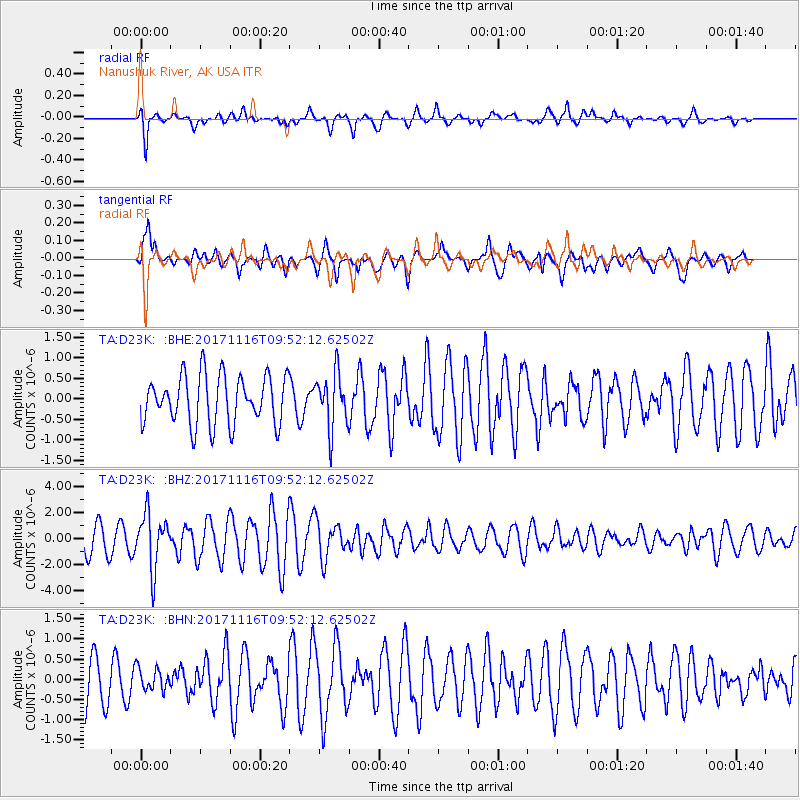
D23K Nanushuk River, AK USA - Earthquake Result Viewer
*The percent match for this event was below the threshold and hence no stack was calculated.
| Earthquake location: |
Southeast Of Honshu, Japan |
| Earthquake latitude/longitude: |
32.2/140.5 |
| Earthquake time(UTC): |
2017/11/16 (320) 09:43:35 GMT |
| Earthquake Depth: |
71 km |
| Earthquake Magnitude: |
5.8 Mww |
| Earthquake Catalog/Contributor: |
NEIC PDE/us |
|
| Network: |
TA USArray Transportable Network (new EarthScope stations) |
| Station: |
D23K Nanushuk River, AK USA |
| Lat/Lon: |
68.97 N/150.68 W |
| Elevation: |
406 m |
|
| Distance: |
52.8 deg |
| Az: |
25.008 deg |
| Baz: |
263.152 deg |
| Ray Param: |
$rayparam |
*The percent match for this event was below the threshold and hence was not used in the summary stack. |
|
| Radial Match: |
74.2546 % |
| Radial Bump: |
400 |
| Transverse Match: |
67.85751 % |
| Transverse Bump: |
400 |
| SOD ConfigId: |
13570011 |
| Insert Time: |
2019-04-29 06:03:26.428 +0000 |
| GWidth: |
2.5 |
| Max Bumps: |
400 |
| Tol: |
0.001 |
|
Signal To Noise
| Channel | StoN | STA | LTA |
| TA:D23K: :BHZ:20171116T09:52:12.62502Z | 2.1995876 | 2.1022113E-6 | 9.557298E-7 |
| TA:D23K: :BHN:20171116T09:52:12.62502Z | 0.53647286 | 2.7223382E-7 | 5.074512E-7 |
| TA:D23K: :BHE:20171116T09:52:12.62502Z | 1.1217715 | 6.6355807E-7 | 5.91527E-7 |
| Arrivals |
| Ps | |
| PpPs | |
| PsPs/PpSs | |


