You are here: Home > Network List > TA - USArray Transportable Network (new EarthScope stations) Stations List
> Station F28M Old Crow, YT, CAN > Earthquake Result Viewer
F28M Old Crow, YT, CAN - Earthquake Result Viewer
| Earthquake location: |
Southeast Of Honshu, Japan |
| Earthquake latitude/longitude: |
32.2/140.5 |
| Earthquake time(UTC): |
2017/11/16 (320) 09:43:35 GMT |
| Earthquake Depth: |
71 km |
| Earthquake Magnitude: |
5.8 Mww |
| Earthquake Catalog/Contributor: |
NEIC PDE/us |
|
| Network: |
TA USArray Transportable Network (new EarthScope stations) |
| Station: |
F28M Old Crow, YT, CAN |
| Lat/Lon: |
67.61 N/139.87 W |
| Elevation: |
564 m |
|
| Distance: |
56.7 deg |
| Az: |
26.777 deg |
| Baz: |
274.212 deg |
| Ray Param: |
0.063749164 |
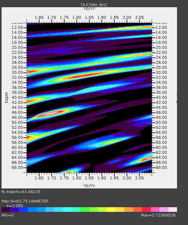
| Estimated Moho Depth: |
63.75 km |
| Estimated Crust Vp/Vs: |
2.10 |
| Assumed Crust Vp: |
6.577 km/s |
| Estimated Crust Vs: |
3.139 km/s |
| Estimated Crust Poisson's Ratio: |
0.35 |
|
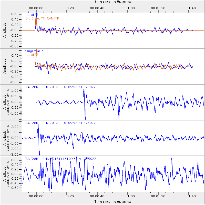
| Radial Match: |
83.46105 % |
| Radial Bump: |
400 |
| Transverse Match: |
64.9384 % |
| Transverse Bump: |
400 |
| SOD ConfigId: |
13570011 |
| Insert Time: |
2019-04-29 06:03:48.453 +0000 |
| GWidth: |
2.5 |
| Max Bumps: |
400 |
| Tol: |
0.001 |
|
Signal To Noise
| Channel | StoN | STA | LTA |
| TA:F28M: :BHZ:20171116T09:52:41.37502Z | 11.201289 | 1.2193211E-6 | 1.0885543E-7 |
| TA:F28M: :BHN:20171116T09:52:41.37502Z | 1.1505105 | 2.1426482E-7 | 1.8623456E-7 |
| TA:F28M: :BHE:20171116T09:52:41.37502Z | 5.679721 | 5.9033397E-7 | 1.0393715E-7 |
| Arrivals |
| Ps | 11 SECOND |
| PpPs | 29 SECOND |
| PsPs/PpSs | 40 SECOND |


