You are here: Home > Network List > TA - USArray Transportable Network (new EarthScope stations) Stations List
> Station X15A Humboldt, AZ, USA > Earthquake Result Viewer
X15A Humboldt, AZ, USA - Earthquake Result Viewer
| Earthquake location: |
Tonga Islands |
| Earthquake latitude/longitude: |
-20.8/-173.3 |
| Earthquake time(UTC): |
2008/06/26 (178) 21:19:15 GMT |
| Earthquake Depth: |
38 km |
| Earthquake Magnitude: |
6.0 MB, 5.8 MS, 6.2 MW, 6.1 MW |
| Earthquake Catalog/Contributor: |
WHDF/NEIC |
|
| Network: |
TA USArray Transportable Network (new EarthScope stations) |
| Station: |
X15A Humboldt, AZ, USA |
| Lat/Lon: |
34.49 N/112.24 W |
| Elevation: |
1332 m |
|
| Distance: |
79.9 deg |
| Az: |
47.266 deg |
| Baz: |
236.318 deg |
| Ray Param: |
0.04856608 |
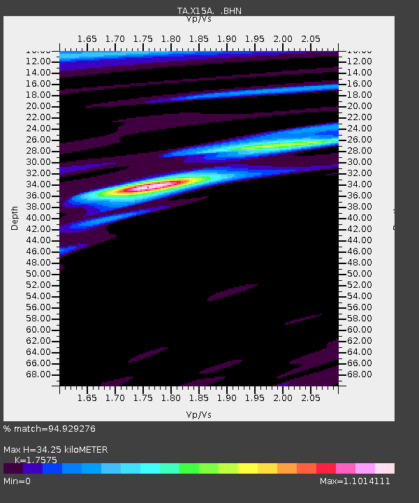
| Estimated Moho Depth: |
34.25 km |
| Estimated Crust Vp/Vs: |
1.76 |
| Assumed Crust Vp: |
6.276 km/s |
| Estimated Crust Vs: |
3.571 km/s |
| Estimated Crust Poisson's Ratio: |
0.26 |
|
| Radial Match: |
94.929276 % |
| Radial Bump: |
400 |
| Transverse Match: |
82.661446 % |
| Transverse Bump: |
400 |
| SOD ConfigId: |
2504 |
| Insert Time: |
2010-03-06 06:38:17.114 +0000 |
| GWidth: |
2.5 |
| Max Bumps: |
400 |
| Tol: |
0.001 |
|

Signal To Noise
| Channel | StoN | STA | LTA |
| TA:X15A: :BHN:20080626T21:30:49.548994Z | 21.96794 | 1.5264103E-6 | 6.948355E-8 |
| TA:X15A: :BHE:20080626T21:30:49.548994Z | 4.1523905 | 3.186511E-7 | 7.67392E-8 |
| TA:X15A: :BHZ:20080626T21:30:49.548994Z | 6.7377515 | 4.5943594E-7 | 6.8188314E-8 |
| Arrivals |
| Ps | 4.2 SECOND |
| PpPs | 15 SECOND |
| PsPs/PpSs | 19 SECOND |


