You are here: Home > Network List > TA - USArray Transportable Network (new EarthScope stations) Stations List
> Station J26L Joseph Creek, AK, USA > Earthquake Result Viewer
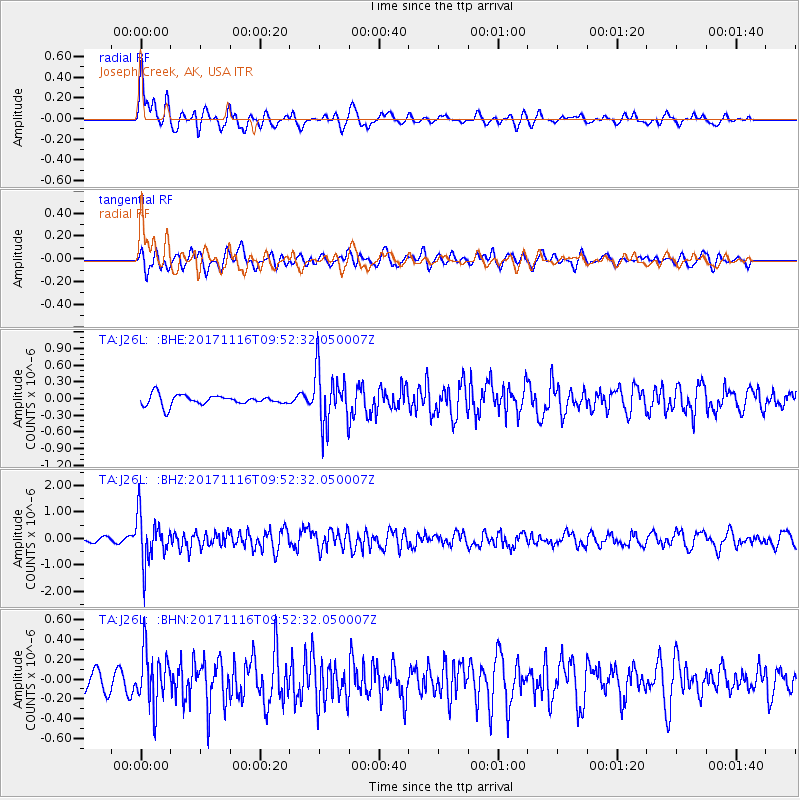
J26L Joseph Creek, AK, USA - Earthquake Result Viewer
*The percent match for this event was below the threshold and hence no stack was calculated.
| Earthquake location: |
Southeast Of Honshu, Japan |
| Earthquake latitude/longitude: |
32.2/140.5 |
| Earthquake time(UTC): |
2017/11/16 (320) 09:43:35 GMT |
| Earthquake Depth: |
71 km |
| Earthquake Magnitude: |
5.8 Mww |
| Earthquake Catalog/Contributor: |
NEIC PDE/us |
|
| Network: |
TA USArray Transportable Network (new EarthScope stations) |
| Station: |
J26L Joseph Creek, AK, USA |
| Lat/Lon: |
64.50 N/143.56 W |
| Elevation: |
1144 m |
|
| Distance: |
55.4 deg |
| Az: |
30.649 deg |
| Baz: |
273.001 deg |
| Ray Param: |
$rayparam |
*The percent match for this event was below the threshold and hence was not used in the summary stack. |
|
| Radial Match: |
69.355995 % |
| Radial Bump: |
400 |
| Transverse Match: |
61.56866 % |
| Transverse Bump: |
400 |
| SOD ConfigId: |
13570011 |
| Insert Time: |
2019-04-29 06:04:25.380 +0000 |
| GWidth: |
2.5 |
| Max Bumps: |
400 |
| Tol: |
0.001 |
|
Signal To Noise
| Channel | StoN | STA | LTA |
| TA:J26L: :BHZ:20171116T09:52:32.050007Z | 12.092252 | 8.8774505E-7 | 7.341437E-8 |
| TA:J26L: :BHN:20171116T09:52:32.050007Z | 3.1707065 | 2.7406526E-7 | 8.643666E-8 |
| TA:J26L: :BHE:20171116T09:52:32.050007Z | 5.4716034 | 4.892066E-7 | 8.9408275E-8 |
| Arrivals |
| Ps | |
| PpPs | |
| PsPs/PpSs | |


