You are here: Home > Network List > TA - USArray Transportable Network (new EarthScope stations) Stations List
> Station K15K Wolf Creek Mountain, AK, USA > Earthquake Result Viewer
K15K Wolf Creek Mountain, AK, USA - Earthquake Result Viewer
| Earthquake location: |
Southeast Of Honshu, Japan |
| Earthquake latitude/longitude: |
32.2/140.5 |
| Earthquake time(UTC): |
2017/11/16 (320) 09:43:35 GMT |
| Earthquake Depth: |
71 km |
| Earthquake Magnitude: |
5.8 Mww |
| Earthquake Catalog/Contributor: |
NEIC PDE/us |
|
| Network: |
TA USArray Transportable Network (new EarthScope stations) |
| Station: |
K15K Wolf Creek Mountain, AK, USA |
| Lat/Lon: |
62.29 N/161.53 W |
| Elevation: |
346 m |
|
| Distance: |
47.2 deg |
| Az: |
32.651 deg |
| Baz: |
258.182 deg |
| Ray Param: |
0.069909975 |
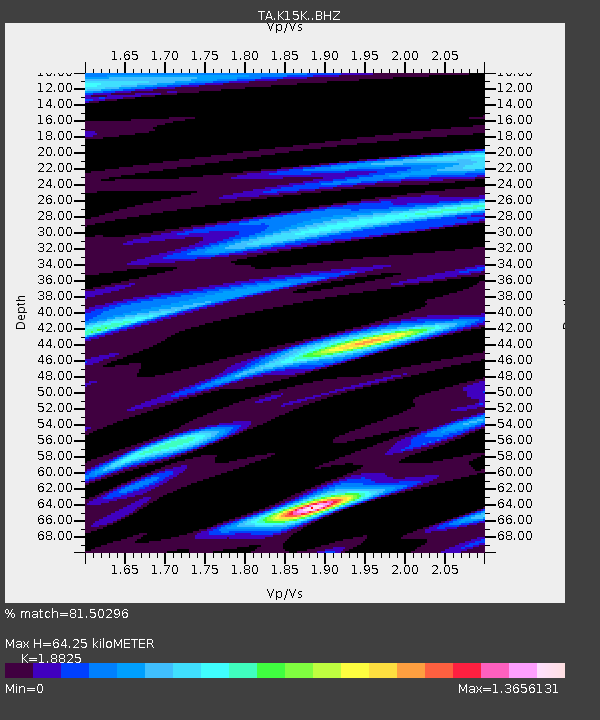
| Estimated Moho Depth: |
64.25 km |
| Estimated Crust Vp/Vs: |
1.88 |
| Assumed Crust Vp: |
6.276 km/s |
| Estimated Crust Vs: |
3.334 km/s |
| Estimated Crust Poisson's Ratio: |
0.30 |
|
| Radial Match: |
81.50296 % |
| Radial Bump: |
400 |
| Transverse Match: |
73.466736 % |
| Transverse Bump: |
371 |
| SOD ConfigId: |
13570011 |
| Insert Time: |
2019-04-29 06:04:27.273 +0000 |
| GWidth: |
2.5 |
| Max Bumps: |
400 |
| Tol: |
0.001 |
|

Signal To Noise
| Channel | StoN | STA | LTA |
| TA:K15K: :BHZ:20171116T09:51:30.825001Z | 9.720241 | 1.7408041E-6 | 1.7909065E-7 |
| TA:K15K: :BHN:20171116T09:51:30.825001Z | 1.6577544 | 3.2105254E-7 | 1.9366713E-7 |
| TA:K15K: :BHE:20171116T09:51:30.825001Z | 5.3089595 | 8.966348E-7 | 1.6889086E-7 |
| Arrivals |
| Ps | 9.5 SECOND |
| PpPs | 28 SECOND |
| PsPs/PpSs | 37 SECOND |


