You are here: Home > Network List > TA - USArray Transportable Network (new EarthScope stations) Stations List
> Station L15K Ungalak Mountain, AK, USA > Earthquake Result Viewer
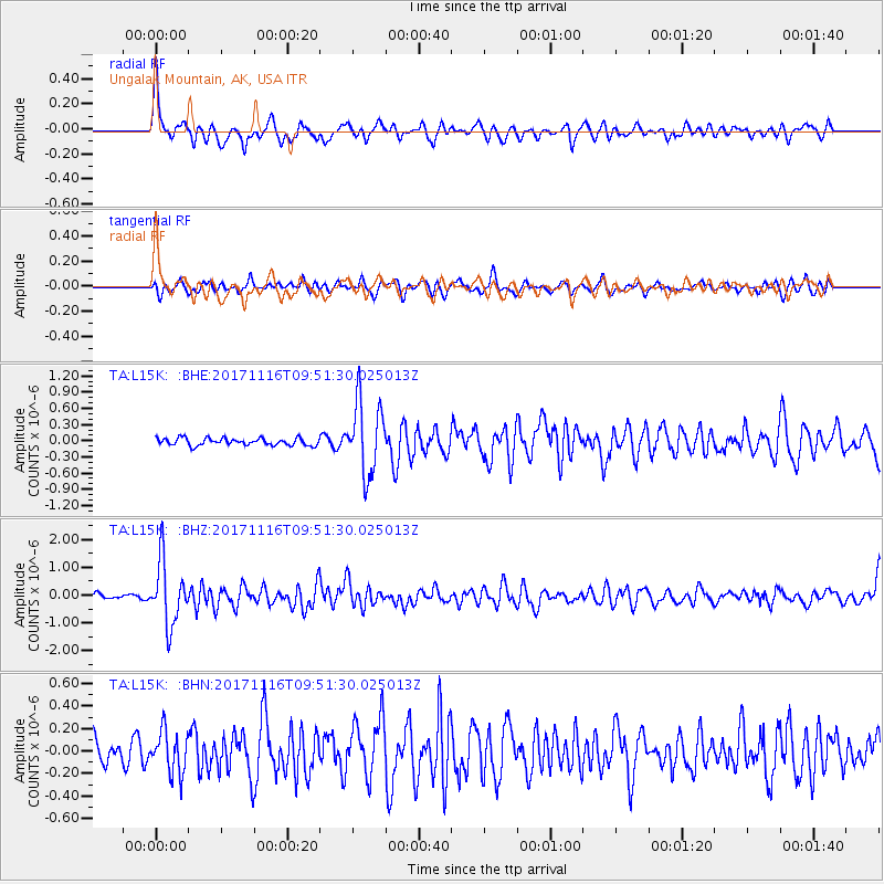
L15K Ungalak Mountain, AK, USA - Earthquake Result Viewer
*The percent match for this event was below the threshold and hence no stack was calculated.
| Earthquake location: |
Southeast Of Honshu, Japan |
| Earthquake latitude/longitude: |
32.2/140.5 |
| Earthquake time(UTC): |
2017/11/16 (320) 09:43:35 GMT |
| Earthquake Depth: |
71 km |
| Earthquake Magnitude: |
5.8 Mww |
| Earthquake Catalog/Contributor: |
NEIC PDE/us |
|
| Network: |
TA USArray Transportable Network (new EarthScope stations) |
| Station: |
L15K Ungalak Mountain, AK, USA |
| Lat/Lon: |
61.68 N/161.49 W |
| Elevation: |
219 m |
|
| Distance: |
47.1 deg |
| Az: |
33.483 deg |
| Baz: |
258.786 deg |
| Ray Param: |
$rayparam |
*The percent match for this event was below the threshold and hence was not used in the summary stack. |
|
| Radial Match: |
77.713036 % |
| Radial Bump: |
397 |
| Transverse Match: |
53.069313 % |
| Transverse Bump: |
400 |
| SOD ConfigId: |
13570011 |
| Insert Time: |
2019-04-29 06:04:34.232 +0000 |
| GWidth: |
2.5 |
| Max Bumps: |
400 |
| Tol: |
0.001 |
|
Signal To Noise
| Channel | StoN | STA | LTA |
| TA:L15K: :BHZ:20171116T09:51:30.025013Z | 8.970479 | 1.1197193E-6 | 1.2482268E-7 |
| TA:L15K: :BHN:20171116T09:51:30.025013Z | 1.5843601 | 1.8612984E-7 | 1.1747951E-7 |
| TA:L15K: :BHE:20171116T09:51:30.025013Z | 9.96538 | 6.611973E-7 | 6.6349436E-8 |
| Arrivals |
| Ps | |
| PpPs | |
| PsPs/PpSs | |


