You are here: Home > Network List > TA - USArray Transportable Network (new EarthScope stations) Stations List
> Station X15A Humboldt, AZ, USA > Earthquake Result Viewer
X15A Humboldt, AZ, USA - Earthquake Result Viewer
| Earthquake location: |
Tonga Islands |
| Earthquake latitude/longitude: |
-15.1/-173.5 |
| Earthquake time(UTC): |
2008/08/19 (232) 16:30:13 GMT |
| Earthquake Depth: |
8.0 km |
| Earthquake Magnitude: |
5.6 MB, 5.9 MS, 6.1 MW, 6.0 MW |
| Earthquake Catalog/Contributor: |
WHDF/NEIC |
|
| Network: |
TA USArray Transportable Network (new EarthScope stations) |
| Station: |
X15A Humboldt, AZ, USA |
| Lat/Lon: |
34.49 N/112.24 W |
| Elevation: |
1332 m |
|
| Distance: |
76.2 deg |
| Az: |
48.208 deg |
| Baz: |
240.678 deg |
| Ray Param: |
0.051141996 |
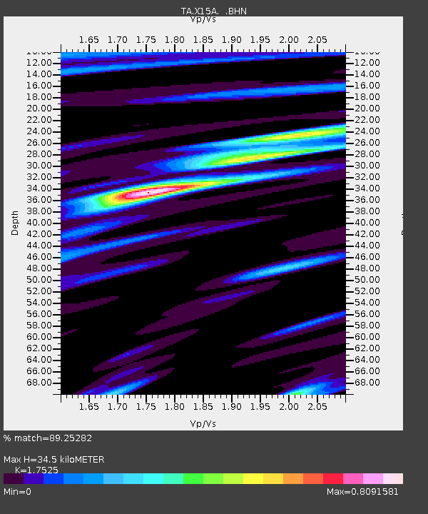
| Estimated Moho Depth: |
34.5 km |
| Estimated Crust Vp/Vs: |
1.75 |
| Assumed Crust Vp: |
6.276 km/s |
| Estimated Crust Vs: |
3.581 km/s |
| Estimated Crust Poisson's Ratio: |
0.26 |
|
| Radial Match: |
89.25282 % |
| Radial Bump: |
373 |
| Transverse Match: |
75.640076 % |
| Transverse Bump: |
400 |
| SOD ConfigId: |
2504 |
| Insert Time: |
2010-03-06 06:38:34.532 +0000 |
| GWidth: |
2.5 |
| Max Bumps: |
400 |
| Tol: |
0.001 |
|

Signal To Noise
| Channel | StoN | STA | LTA |
| TA:X15A: :BHN:20080819T16:41:30.675027Z | 8.659715 | 5.732251E-7 | 6.619446E-8 |
| TA:X15A: :BHE:20080819T16:41:30.675027Z | 3.0808432 | 1.4585663E-7 | 4.734309E-8 |
| TA:X15A: :BHZ:20080819T16:41:30.675027Z | 4.647345 | 1.9782897E-7 | 4.256817E-8 |
| Arrivals |
| Ps | 4.3 SECOND |
| PpPs | 15 SECOND |
| PsPs/PpSs | 19 SECOND |


