You are here: Home > Network List > TA - USArray Transportable Network (new EarthScope stations) Stations List
> Station X15A Humboldt, AZ, USA > Earthquake Result Viewer
X15A Humboldt, AZ, USA - Earthquake Result Viewer
| Earthquake location: |
Fiji Islands Region |
| Earthquake latitude/longitude: |
-21.2/-178.8 |
| Earthquake time(UTC): |
2007/11/19 (323) 00:52:12 GMT |
| Earthquake Depth: |
558 km |
| Earthquake Magnitude: |
6.2 MB, 6.3 MW, 6.3 MW |
| Earthquake Catalog/Contributor: |
WHDF/NEIC |
|
| Network: |
TA USArray Transportable Network (new EarthScope stations) |
| Station: |
X15A Humboldt, AZ, USA |
| Lat/Lon: |
34.49 N/112.24 W |
| Elevation: |
1332 m |
|
| Distance: |
84.0 deg |
| Az: |
49.622 deg |
| Baz: |
239.391 deg |
| Ray Param: |
0.04417544 |
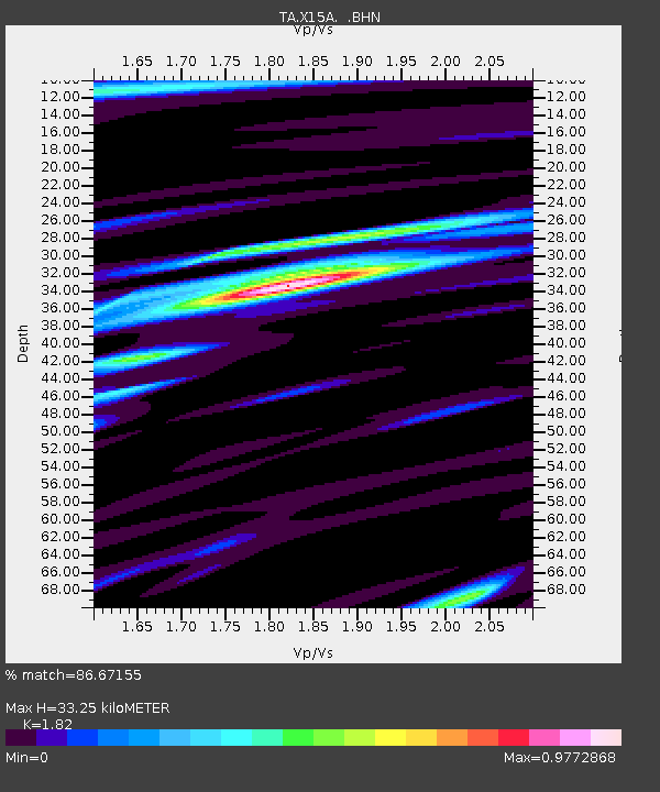
| Estimated Moho Depth: |
33.25 km |
| Estimated Crust Vp/Vs: |
1.82 |
| Assumed Crust Vp: |
6.276 km/s |
| Estimated Crust Vs: |
3.448 km/s |
| Estimated Crust Poisson's Ratio: |
0.28 |
|
| Radial Match: |
86.67155 % |
| Radial Bump: |
400 |
| Transverse Match: |
57.429157 % |
| Transverse Bump: |
400 |
| SOD ConfigId: |
2564 |
| Insert Time: |
2010-03-06 06:38:56.659 +0000 |
| GWidth: |
2.5 |
| Max Bumps: |
400 |
| Tol: |
0.001 |
|
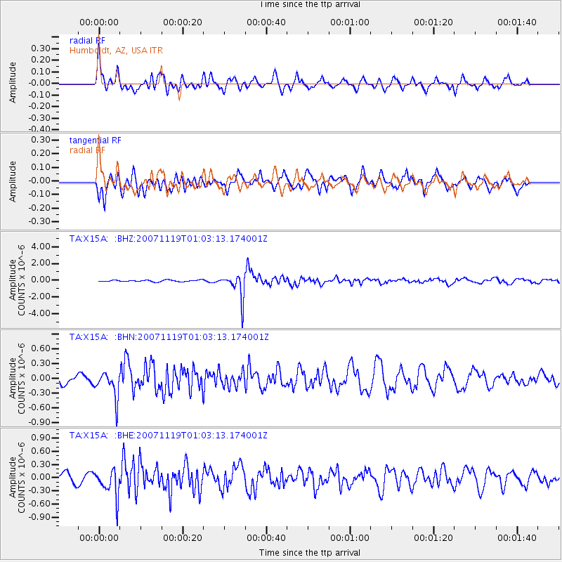
Signal To Noise
| Channel | StoN | STA | LTA |
| TA:X15A: :BHN:20071119T01:03:13.174001Z | 1.8135906 | 2.7578216E-7 | 1.5206417E-7 |
| TA:X15A: :BHE:20071119T01:03:13.174001Z | 3.025435 | 3.203164E-7 | 1.05874484E-7 |
| TA:X15A: :BHZ:20071119T01:03:13.174001Z | 16.632753 | 1.5116151E-6 | 9.088183E-8 |
| Arrivals |
| Ps | 4.4 SECOND |
| PpPs | 15 SECOND |
| PsPs/PpSs | 19 SECOND |


