You are here: Home > Network List > TA - USArray Transportable Network (new EarthScope stations) Stations List
> Station R32K Eaglecrest, AK, USA > Earthquake Result Viewer
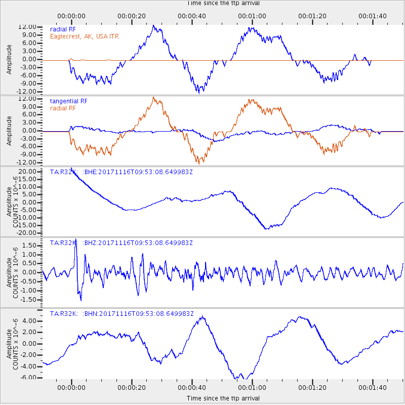
R32K Eaglecrest, AK, USA - Earthquake Result Viewer
*The percent match for this event was below the threshold and hence no stack was calculated.
| Earthquake location: |
Southeast Of Honshu, Japan |
| Earthquake latitude/longitude: |
32.2/140.5 |
| Earthquake time(UTC): |
2017/11/16 (320) 09:43:35 GMT |
| Earthquake Depth: |
71 km |
| Earthquake Magnitude: |
5.8 Mww |
| Earthquake Catalog/Contributor: |
NEIC PDE/us |
|
| Network: |
TA USArray Transportable Network (new EarthScope stations) |
| Station: |
R32K Eaglecrest, AK, USA |
| Lat/Lon: |
58.27 N/134.52 W |
| Elevation: |
386 m |
|
| Distance: |
60.7 deg |
| Az: |
37.131 deg |
| Baz: |
284.381 deg |
| Ray Param: |
$rayparam |
*The percent match for this event was below the threshold and hence was not used in the summary stack. |
|
| Radial Match: |
59.075966 % |
| Radial Bump: |
400 |
| Transverse Match: |
21.366089 % |
| Transverse Bump: |
400 |
| SOD ConfigId: |
13570011 |
| Insert Time: |
2019-04-29 06:05:31.145 +0000 |
| GWidth: |
2.5 |
| Max Bumps: |
400 |
| Tol: |
0.001 |
|
Signal To Noise
| Channel | StoN | STA | LTA |
| TA:R32K: :BHZ:20171116T09:53:08.649983Z | 3.8962286 | 9.0062554E-7 | 2.3115315E-7 |
| TA:R32K: :BHN:20171116T09:53:08.649983Z | 0.2618028 | 7.762702E-7 | 2.9650953E-6 |
| TA:R32K: :BHE:20171116T09:53:08.649983Z | 0.1891613 | 1.5149035E-6 | 8.008527E-6 |
| Arrivals |
| Ps | |
| PpPs | |
| PsPs/PpSs | |


