You are here: Home > Network List > TA - USArray Transportable Network (new EarthScope stations) Stations List
> Station TPFO Pinon Flats, CA, USA > Earthquake Result Viewer
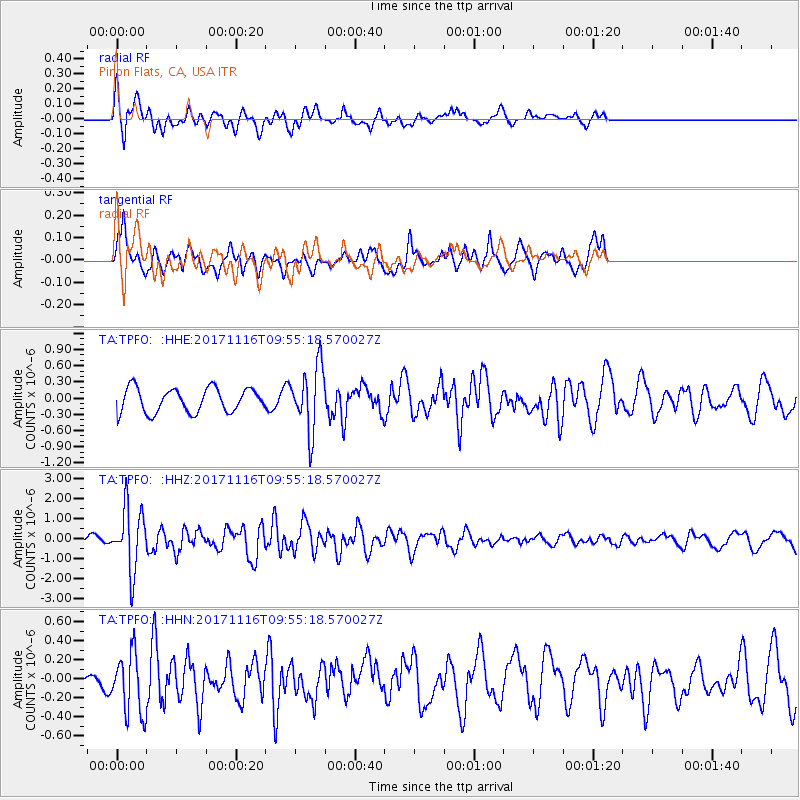
TPFO Pinon Flats, CA, USA - Earthquake Result Viewer
*The percent match for this event was below the threshold and hence no stack was calculated.
| Earthquake location: |
Southeast Of Honshu, Japan |
| Earthquake latitude/longitude: |
32.2/140.5 |
| Earthquake time(UTC): |
2017/11/16 (320) 09:43:35 GMT |
| Earthquake Depth: |
71 km |
| Earthquake Magnitude: |
5.8 Mww |
| Earthquake Catalog/Contributor: |
NEIC PDE/us |
|
| Network: |
TA USArray Transportable Network (new EarthScope stations) |
| Station: |
TPFO Pinon Flats, CA, USA |
| Lat/Lon: |
33.61 N/116.45 W |
| Elevation: |
1275 m |
|
| Distance: |
82.4 deg |
| Az: |
55.131 deg |
| Baz: |
303.53 deg |
| Ray Param: |
$rayparam |
*The percent match for this event was below the threshold and hence was not used in the summary stack. |
|
| Radial Match: |
64.477516 % |
| Radial Bump: |
400 |
| Transverse Match: |
59.179806 % |
| Transverse Bump: |
400 |
| SOD ConfigId: |
13570011 |
| Insert Time: |
2019-04-29 06:05:39.942 +0000 |
| GWidth: |
2.5 |
| Max Bumps: |
400 |
| Tol: |
0.001 |
|
Signal To Noise
| Channel | StoN | STA | LTA |
| TA:TPFO: :HHZ:20171116T09:55:18.570027Z | 6.2080564 | 1.5453188E-6 | 2.489215E-7 |
| TA:TPFO: :HHN:20171116T09:55:18.570027Z | 1.4295607 | 3.1814585E-7 | 2.2254798E-7 |
| TA:TPFO: :HHE:20171116T09:55:18.570027Z | 2.6705475 | 5.9685175E-7 | 2.2349415E-7 |
| Arrivals |
| Ps | |
| PpPs | |
| PsPs/PpSs | |


