You are here: Home > Network List > UW - Pacific Northwest Regional Seismic Network Stations List
> Station MRBL Marblemount, WA, USA > Earthquake Result Viewer
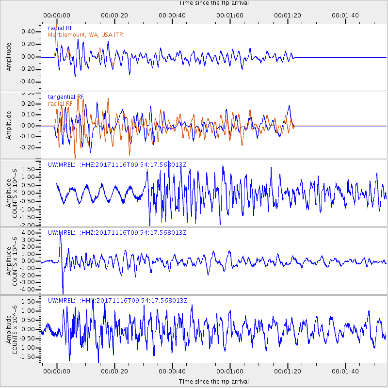
MRBL Marblemount, WA, USA - Earthquake Result Viewer
*The percent match for this event was below the threshold and hence no stack was calculated.
| Earthquake location: |
Southeast Of Honshu, Japan |
| Earthquake latitude/longitude: |
32.2/140.5 |
| Earthquake time(UTC): |
2017/11/16 (320) 09:43:35 GMT |
| Earthquake Depth: |
71 km |
| Earthquake Magnitude: |
5.8 Mww |
| Earthquake Catalog/Contributor: |
NEIC PDE/us |
|
| Network: |
UW Pacific Northwest Regional Seismic Network |
| Station: |
MRBL Marblemount, WA, USA |
| Lat/Lon: |
48.52 N/121.48 W |
| Elevation: |
75 m |
|
| Distance: |
71.5 deg |
| Az: |
43.984 deg |
| Baz: |
297.667 deg |
| Ray Param: |
$rayparam |
*The percent match for this event was below the threshold and hence was not used in the summary stack. |
|
| Radial Match: |
77.17455 % |
| Radial Bump: |
400 |
| Transverse Match: |
64.47612 % |
| Transverse Bump: |
400 |
| SOD ConfigId: |
13570011 |
| Insert Time: |
2019-04-29 06:06:39.486 +0000 |
| GWidth: |
2.5 |
| Max Bumps: |
400 |
| Tol: |
0.001 |
|
Signal To Noise
| Channel | StoN | STA | LTA |
| UW:MRBL: :HHZ:20171116T09:54:17.568013Z | 4.997759 | 1.687147E-6 | 3.3758073E-7 |
| UW:MRBL: :HHN:20171116T09:54:17.568013Z | 2.2265165 | 6.3593825E-7 | 2.856203E-7 |
| UW:MRBL: :HHE:20171116T09:54:17.568013Z | 2.2896326 | 7.6837557E-7 | 3.3558902E-7 |
| Arrivals |
| Ps | |
| PpPs | |
| PsPs/PpSs | |


