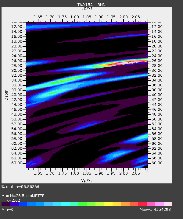
X15A Humboldt, AZ, USA - Earthquake Result Viewer

Earthquake location: Fox Islands, Aleutian Islands
Earthquake latitude/longitude: 52.5/-168.0
Earthquake time(UTC): 2007/07/15 (196) 13:08:00 GMT
Earthquake Depth: 10 km
Earthquake Magnitude: 5.8 MB, 5.9 MS, 6.1 MW, 6.0 MW
Earthquake Catalog/Contributor: WHDF/NEIC
Network: TA USArray Transportable Network (new EarthScope stations)
Station: X15A Humboldt, AZ, USA
Lat/Lon: 34.49 N/112.24 W
Elevation: 1332 m
Distance: 43.1 deg
Az: 91.886 deg
Baz: 312.265 deg
Ray Param: 0.07275104
Estimated Moho Depth: 26.5 km
Estimated Crust Vp/Vs: 2.02
Assumed Crust Vp: 6.276 km/s
Estimated Crust Vs: 3.107 km/s
Estimated Crust Poisson's Ratio: 0.34
Radial Match: 96.86356 %
Radial Bump: 362
Transverse Match: 86.47155 %
Transverse Bump: 400
SOD ConfigId: 2564
Insert Time: 2010-03-06 06:39:48.899 +0000
GWidth: 2.5
Max Bumps: 400
Tol: 0.001

Signal To Noise

ChannelStoNSTALTA
TA:X15A: :BHN:20070715T13:15:30.398013Z4.5163381.2530535E-72.7744901E-8
TA:X15A: :BHE:20070715T13:15:30.398013Z3.4814861.196187E-73.4358518E-8
TA:X15A: :BHZ:20070715T13:15:30.398013Z5.65272052.832733E-75.0112742E-8
Arrivals
Ps4.6 SECOND
PpPs12 SECOND
PsPs/PpSs17 SECOND