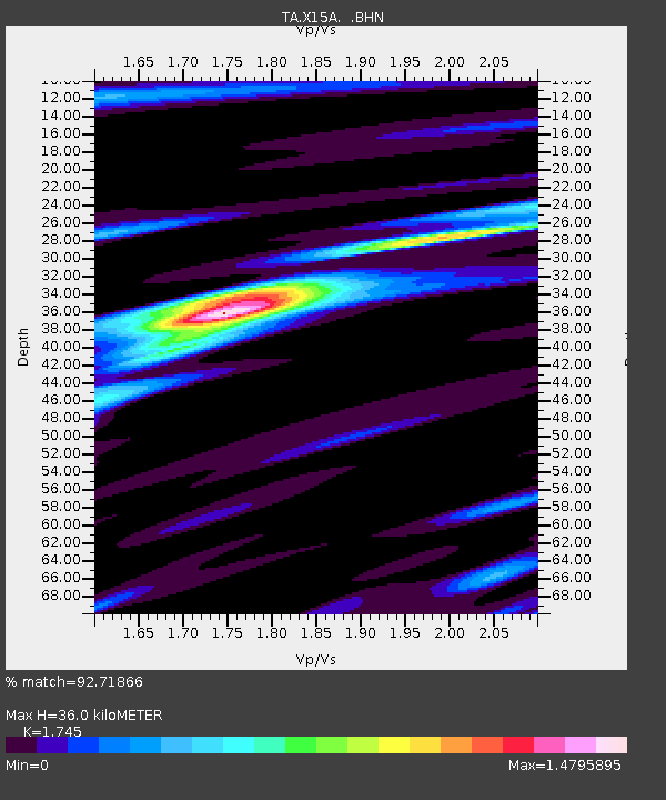
X15A Humboldt, AZ, USA - Earthquake Result Viewer

Earthquake location: Andreanof Islands, Aleutian Is.
Earthquake latitude/longitude: 51.8/-176.3
Earthquake time(UTC): 2007/07/13 (194) 21:54:43 GMT
Earthquake Depth: 35 km
Earthquake Magnitude: 5.7 MB, 5.6 MS, 6.0 MW, 5.9 MW
Earthquake Catalog/Contributor: WHDF/NEIC
Network: TA USArray Transportable Network (new EarthScope stations)
Station: X15A Humboldt, AZ, USA
Lat/Lon: 34.49 N/112.24 W
Elevation: 1332 m
Distance: 48.2 deg
Az: 84.909 deg
Baz: 311.568 deg
Ray Param: 0.0694352
Estimated Moho Depth: 36.0 km
Estimated Crust Vp/Vs: 1.75
Assumed Crust Vp: 6.276 km/s
Estimated Crust Vs: 3.596 km/s
Estimated Crust Poisson's Ratio: 0.26
Radial Match: 92.71866 %
Radial Bump: 386
Transverse Match: 56.534527 %
Transverse Bump: 400
SOD ConfigId: 2564
Insert Time: 2010-03-06 06:39:54.880 +0000
GWidth: 2.5
Max Bumps: 400
Tol: 0.001

Signal To Noise

ChannelStoNSTALTA
TA:X15A: :BHN:20070713T22:02:49.750015Z5.81725551.737613E-72.986998E-8
TA:X15A: :BHE:20070713T22:02:49.750015Z3.3678021.6710486E-74.961837E-8
TA:X15A: :BHZ:20070713T22:02:49.750015Z6.13454.072176E-76.638155E-8
Arrivals
Ps4.5 SECOND
PpPs15 SECOND
PsPs/PpSs19 SECOND