You are here: Home > Network List > US - United States National Seismic Network Stations List
> Station EGMT Eagleton, Montana, USA > Earthquake Result Viewer
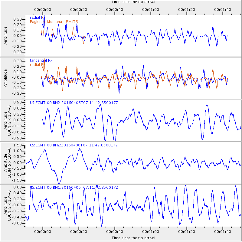
EGMT Eagleton, Montana, USA - Earthquake Result Viewer
*The percent match for this event was below the threshold and hence no stack was calculated.
| Earthquake location: |
Vanuatu Islands |
| Earthquake latitude/longitude: |
-14.1/166.6 |
| Earthquake time(UTC): |
2016/04/06 (097) 06:58:48 GMT |
| Earthquake Depth: |
24 km |
| Earthquake Magnitude: |
6.7 MWW, 6.6 MWB, 6.7 MWC, 6.9 MI |
| Earthquake Catalog/Contributor: |
NEIC PDE/NEIC COMCAT |
|
| Network: |
US United States National Seismic Network |
| Station: |
EGMT Eagleton, Montana, USA |
| Lat/Lon: |
48.02 N/109.75 W |
| Elevation: |
1055 m |
|
| Distance: |
96.1 deg |
| Az: |
42.147 deg |
| Baz: |
255.919 deg |
| Ray Param: |
$rayparam |
*The percent match for this event was below the threshold and hence was not used in the summary stack. |
|
| Radial Match: |
57.191303 % |
| Radial Bump: |
400 |
| Transverse Match: |
40.306396 % |
| Transverse Bump: |
400 |
| SOD ConfigId: |
1475611 |
| Insert Time: |
2016-04-20 07:20:38.425 +0000 |
| GWidth: |
2.5 |
| Max Bumps: |
400 |
| Tol: |
0.001 |
|
Signal To Noise
| Channel | StoN | STA | LTA |
| US:EGMT:00:BHZ:20160406T07:11:42.850017Z | 4.0028625 | 7.4237147E-7 | 1.8546015E-7 |
| US:EGMT:00:BH1:20160406T07:11:42.850017Z | 0.35233825 | 1.2869323E-7 | 3.652548E-7 |
| US:EGMT:00:BH2:20160406T07:11:42.850017Z | 1.6805632 | 6.091589E-7 | 3.624731E-7 |
| Arrivals |
| Ps | |
| PpPs | |
| PsPs/PpSs | |


