You are here: Home > Network List > TA - USArray Transportable Network (new EarthScope stations) Stations List
> Station X15A Humboldt, AZ, USA > Earthquake Result Viewer
X15A Humboldt, AZ, USA - Earthquake Result Viewer
| Earthquake location: |
Santiago Del Estero Prov., Arg. |
| Earthquake latitude/longitude: |
-26.0/-63.2 |
| Earthquake time(UTC): |
2006/11/13 (317) 01:26:34 GMT |
| Earthquake Depth: |
552 km |
| Earthquake Magnitude: |
6.3 MB, 6.8 MW, 6.8 MW |
| Earthquake Catalog/Contributor: |
WHDF/NEIC |
|
| Network: |
TA USArray Transportable Network (new EarthScope stations) |
| Station: |
X15A Humboldt, AZ, USA |
| Lat/Lon: |
34.49 N/112.24 W |
| Elevation: |
1332 m |
|
| Distance: |
76.0 deg |
| Az: |
320.018 deg |
| Baz: |
135.589 deg |
| Ray Param: |
0.04952001 |
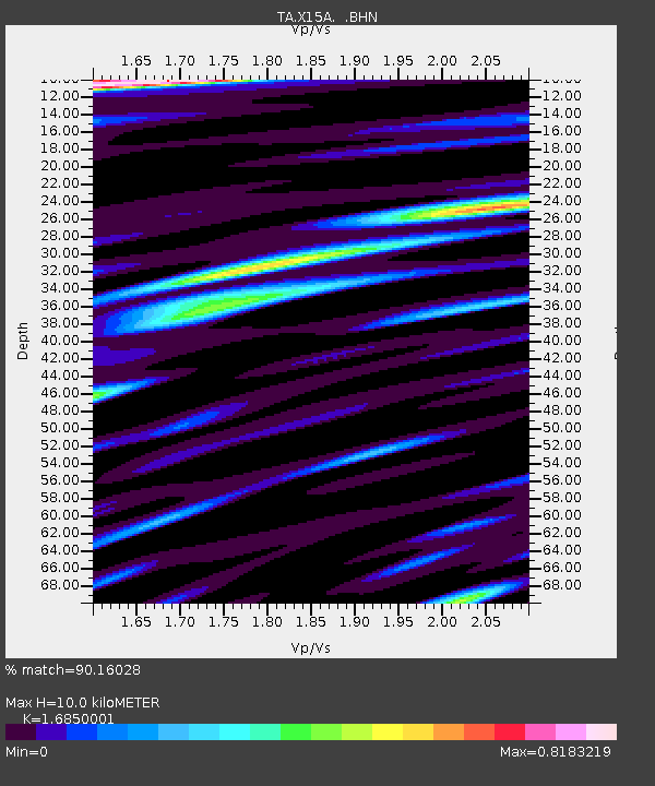
| Estimated Moho Depth: |
10.0 km |
| Estimated Crust Vp/Vs: |
1.69 |
| Assumed Crust Vp: |
6.276 km/s |
| Estimated Crust Vs: |
3.725 km/s |
| Estimated Crust Poisson's Ratio: |
0.23 |
|
| Radial Match: |
90.16028 % |
| Radial Bump: |
400 |
| Transverse Match: |
66.28339 % |
| Transverse Bump: |
400 |
| SOD ConfigId: |
2564 |
| Insert Time: |
2010-03-06 06:40:21.831 +0000 |
| GWidth: |
2.5 |
| Max Bumps: |
400 |
| Tol: |
0.001 |
|

Signal To Noise
| Channel | StoN | STA | LTA |
| TA:X15A: :BHN:20061113T01:36:54.100024Z | 0.6642633 | 1.1611593E-7 | 1.7480407E-7 |
| TA:X15A: :BHE:20061113T01:36:54.100024Z | 0.9414523 | 1.9941538E-7 | 2.1181675E-7 |
| TA:X15A: :BHZ:20061113T01:36:54.100024Z | 1.5615703 | 4.4172126E-7 | 2.8286993E-7 |
| Arrivals |
| Ps | 1.1 SECOND |
| PpPs | 4.2 SECOND |
| PsPs/PpSs | 5.3 SECOND |


