You are here: Home > Network List > TA - USArray Transportable Network (new EarthScope stations) Stations List
> Station F26K Sheenjek River, AK, USA > Earthquake Result Viewer
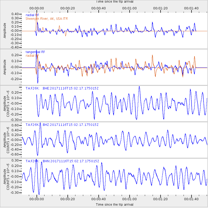
F26K Sheenjek River, AK, USA - Earthquake Result Viewer
*The percent match for this event was below the threshold and hence no stack was calculated.
| Earthquake location: |
Solomon Islands |
| Earthquake latitude/longitude: |
-10.1/160.9 |
| Earthquake time(UTC): |
2017/11/16 (320) 14:50:04 GMT |
| Earthquake Depth: |
10 km |
| Earthquake Magnitude: |
5.6 mb |
| Earthquake Catalog/Contributor: |
NEIC PDE/us |
|
| Network: |
TA USArray Transportable Network (new EarthScope stations) |
| Station: |
F26K Sheenjek River, AK, USA |
| Lat/Lon: |
67.69 N/144.15 W |
| Elevation: |
683 m |
|
| Distance: |
86.8 deg |
| Az: |
18.232 deg |
| Baz: |
233.817 deg |
| Ray Param: |
$rayparam |
*The percent match for this event was below the threshold and hence was not used in the summary stack. |
|
| Radial Match: |
54.23497 % |
| Radial Bump: |
400 |
| Transverse Match: |
53.097973 % |
| Transverse Bump: |
393 |
| SOD ConfigId: |
13570011 |
| Insert Time: |
2019-04-29 06:11:29.149 +0000 |
| GWidth: |
2.5 |
| Max Bumps: |
400 |
| Tol: |
0.001 |
|
Signal To Noise
| Channel | StoN | STA | LTA |
| TA:F26K: :BHZ:20171116T15:02:17.175015Z | 3.3063881 | 3.9600047E-7 | 1.1976829E-7 |
| TA:F26K: :BHN:20171116T15:02:17.175015Z | 1.7344748 | 2.1718301E-7 | 1.2521544E-7 |
| TA:F26K: :BHE:20171116T15:02:17.175015Z | 0.47515875 | 5.0944447E-8 | 1.07215634E-7 |
| Arrivals |
| Ps | |
| PpPs | |
| PsPs/PpSs | |


