You are here: Home > Network List > TA - USArray Transportable Network (new EarthScope stations) Stations List
> Station J25K Salcha River, AK, USA > Earthquake Result Viewer
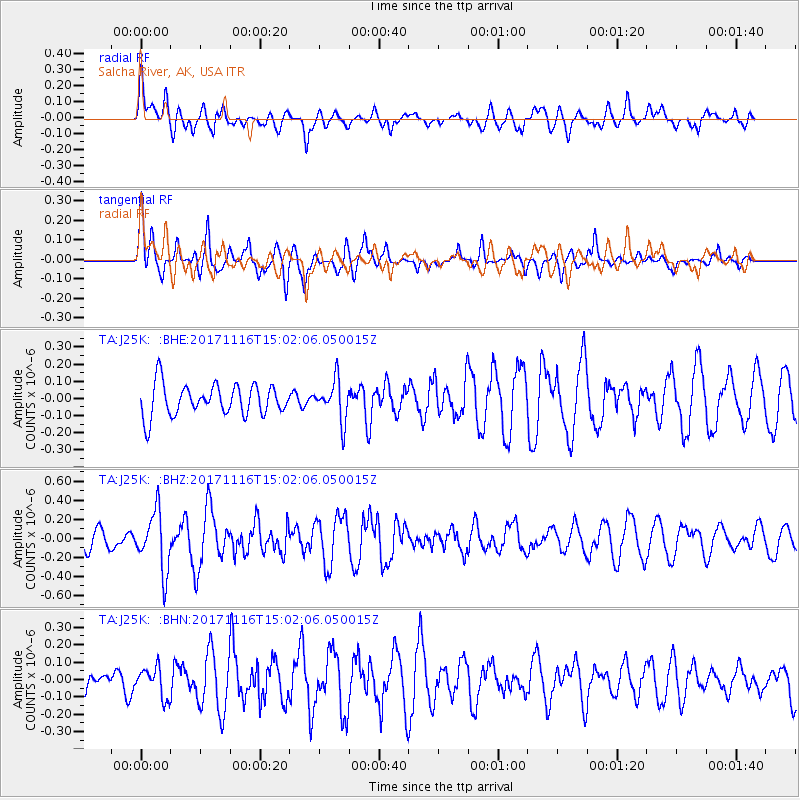
J25K Salcha River, AK, USA - Earthquake Result Viewer
*The percent match for this event was below the threshold and hence no stack was calculated.
| Earthquake location: |
Solomon Islands |
| Earthquake latitude/longitude: |
-10.1/160.9 |
| Earthquake time(UTC): |
2017/11/16 (320) 14:50:04 GMT |
| Earthquake Depth: |
10 km |
| Earthquake Magnitude: |
5.6 mb |
| Earthquake Catalog/Contributor: |
NEIC PDE/us |
|
| Network: |
TA USArray Transportable Network (new EarthScope stations) |
| Station: |
J25K Salcha River, AK, USA |
| Lat/Lon: |
64.61 N/145.37 W |
| Elevation: |
949 m |
|
| Distance: |
84.6 deg |
| Az: |
20.424 deg |
| Baz: |
232.862 deg |
| Ray Param: |
$rayparam |
*The percent match for this event was below the threshold and hence was not used in the summary stack. |
|
| Radial Match: |
45.429085 % |
| Radial Bump: |
400 |
| Transverse Match: |
58.38474 % |
| Transverse Bump: |
400 |
| SOD ConfigId: |
13570011 |
| Insert Time: |
2019-04-29 06:11:40.161 +0000 |
| GWidth: |
2.5 |
| Max Bumps: |
400 |
| Tol: |
0.001 |
|
Signal To Noise
| Channel | StoN | STA | LTA |
| TA:J25K: :BHZ:20171116T15:02:06.050015Z | 2.3741064 | 3.1159826E-7 | 1.3124864E-7 |
| TA:J25K: :BHN:20171116T15:02:06.050015Z | 0.79234797 | 8.561963E-8 | 1.08058124E-7 |
| TA:J25K: :BHE:20171116T15:02:06.050015Z | 1.2849889 | 1.1710072E-7 | 9.1129756E-8 |
| Arrivals |
| Ps | |
| PpPs | |
| PsPs/PpSs | |


