You are here: Home > Network List > TA - USArray Transportable Network (new EarthScope stations) Stations List
> Station L20K Farewell, AK, USA > Earthquake Result Viewer
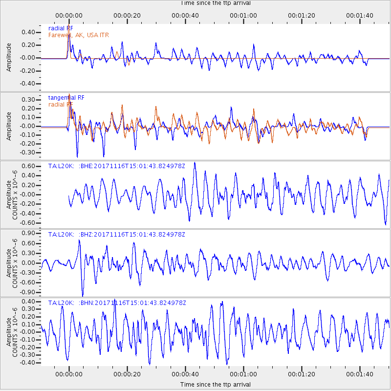
L20K Farewell, AK, USA - Earthquake Result Viewer
*The percent match for this event was below the threshold and hence no stack was calculated.
| Earthquake location: |
Solomon Islands |
| Earthquake latitude/longitude: |
-10.1/160.9 |
| Earthquake time(UTC): |
2017/11/16 (320) 14:50:04 GMT |
| Earthquake Depth: |
10 km |
| Earthquake Magnitude: |
5.6 mb |
| Earthquake Catalog/Contributor: |
NEIC PDE/us |
|
| Network: |
TA USArray Transportable Network (new EarthScope stations) |
| Station: |
L20K Farewell, AK, USA |
| Lat/Lon: |
62.48 N/153.88 W |
| Elevation: |
673 m |
|
| Distance: |
80.3 deg |
| Az: |
19.531 deg |
| Baz: |
225.132 deg |
| Ray Param: |
$rayparam |
*The percent match for this event was below the threshold and hence was not used in the summary stack. |
|
| Radial Match: |
49.96508 % |
| Radial Bump: |
388 |
| Transverse Match: |
63.044662 % |
| Transverse Bump: |
400 |
| SOD ConfigId: |
13570011 |
| Insert Time: |
2019-04-29 06:11:46.208 +0000 |
| GWidth: |
2.5 |
| Max Bumps: |
400 |
| Tol: |
0.001 |
|
Signal To Noise
| Channel | StoN | STA | LTA |
| TA:L20K: :BHZ:20171116T15:01:43.824978Z | 2.87329 | 3.7713815E-7 | 1.3125656E-7 |
| TA:L20K: :BHN:20171116T15:01:43.824978Z | 1.1904364 | 1.8335355E-7 | 1.5402213E-7 |
| TA:L20K: :BHE:20171116T15:01:43.824978Z | 1.3634596 | 2.2329398E-7 | 1.6377014E-7 |
| Arrivals |
| Ps | |
| PpPs | |
| PsPs/PpSs | |


