You are here: Home > Network List > TA - USArray Transportable Network (new EarthScope stations) Stations List
> Station X15A Humboldt, AZ, USA > Earthquake Result Viewer
X15A Humboldt, AZ, USA - Earthquake Result Viewer
| Earthquake location: |
Sea Of Japan |
| Earthquake latitude/longitude: |
41.4/135.7 |
| Earthquake time(UTC): |
2006/09/16 (259) 02:22:50 GMT |
| Earthquake Depth: |
367 km |
| Earthquake Magnitude: |
5.4 MB, 5.9 MW, 5.9 MW |
| Earthquake Catalog/Contributor: |
WHDF/NEIC |
|
| Network: |
TA USArray Transportable Network (new EarthScope stations) |
| Station: |
X15A Humboldt, AZ, USA |
| Lat/Lon: |
34.49 N/112.24 W |
| Elevation: |
1332 m |
|
| Distance: |
82.1 deg |
| Az: |
50.611 deg |
| Baz: |
315.229 deg |
| Ray Param: |
0.046140585 |
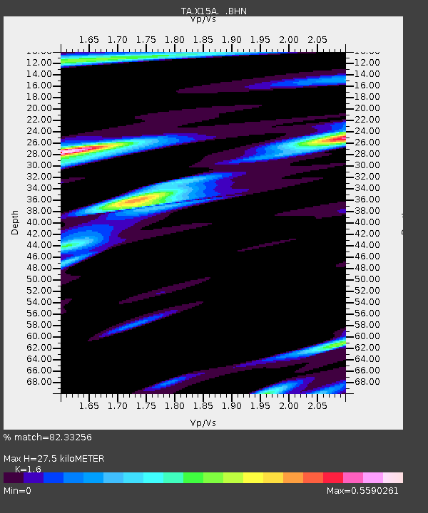
| Estimated Moho Depth: |
27.5 km |
| Estimated Crust Vp/Vs: |
1.60 |
| Assumed Crust Vp: |
6.276 km/s |
| Estimated Crust Vs: |
3.922 km/s |
| Estimated Crust Poisson's Ratio: |
0.18 |
|
| Radial Match: |
82.33256 % |
| Radial Bump: |
400 |
| Transverse Match: |
71.87237 % |
| Transverse Bump: |
400 |
| SOD ConfigId: |
2665 |
| Insert Time: |
2010-03-06 06:40:45.880 +0000 |
| GWidth: |
2.5 |
| Max Bumps: |
400 |
| Tol: |
0.001 |
|
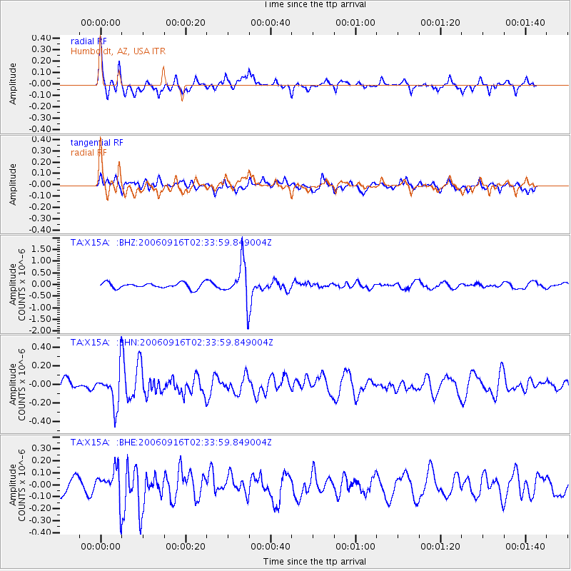
Signal To Noise
| Channel | StoN | STA | LTA |
| TA:X15A: :BHN:20060916T02:33:59.849004Z | 3.0422442 | 1.97602E-7 | 6.4952715E-8 |
| TA:X15A: :BHE:20060916T02:33:59.849004Z | 1.9490943 | 1.3958636E-7 | 7.1616014E-8 |
| TA:X15A: :BHZ:20060916T02:33:59.849004Z | 6.8021235 | 8.381287E-7 | 1.2321574E-7 |
| Arrivals |
| Ps | 2.7 SECOND |
| PpPs | 11 SECOND |
| PsPs/PpSs | 14 SECOND |


