You are here: Home > Network List > TA - USArray Transportable Network (new EarthScope stations) Stations List
> Station X15A Humboldt, AZ, USA > Earthquake Result Viewer
X15A Humboldt, AZ, USA - Earthquake Result Viewer
| Earthquake location: |
Fiji Islands Region |
| Earthquake latitude/longitude: |
-19.9/-178.3 |
| Earthquake time(UTC): |
2006/06/27 (178) 02:59:15 GMT |
| Earthquake Depth: |
570 km |
| Earthquake Magnitude: |
6.0 MB, 6.2 MW |
| Earthquake Catalog/Contributor: |
WHDF/NEIC |
|
| Network: |
TA USArray Transportable Network (new EarthScope stations) |
| Station: |
X15A Humboldt, AZ, USA |
| Lat/Lon: |
34.49 N/112.24 W |
| Elevation: |
1332 m |
|
| Distance: |
82.8 deg |
| Az: |
49.543 deg |
| Baz: |
240.113 deg |
| Ray Param: |
0.044940863 |
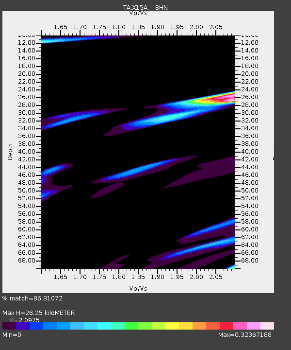
| Estimated Moho Depth: |
26.25 km |
| Estimated Crust Vp/Vs: |
2.10 |
| Assumed Crust Vp: |
6.276 km/s |
| Estimated Crust Vs: |
2.992 km/s |
| Estimated Crust Poisson's Ratio: |
0.35 |
|
| Radial Match: |
86.81072 % |
| Radial Bump: |
400 |
| Transverse Match: |
95.41075 % |
| Transverse Bump: |
272 |
| SOD ConfigId: |
2665 |
| Insert Time: |
2010-03-06 06:40:56.953 +0000 |
| GWidth: |
2.5 |
| Max Bumps: |
400 |
| Tol: |
0.001 |
|

Signal To Noise
| Channel | StoN | STA | LTA |
| TA:X15A: :BHN:20060627T03:10:09.099001Z | 1.3788345 | 2.0831117E-6 | 1.5107771E-6 |
| TA:X15A: :BHE:20060627T03:10:09.099001Z | 1.6119938 | 1.5745688E-6 | 9.767834E-7 |
| TA:X15A: :BHZ:20060627T03:10:09.099001Z | 1.835445 | 2.397725E-6 | 1.3063453E-6 |
| Arrivals |
| Ps | 4.7 SECOND |
| PpPs | 13 SECOND |
| PsPs/PpSs | 17 SECOND |


