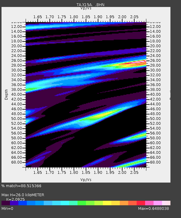
X15A Humboldt, AZ, USA - Earthquake Result Viewer
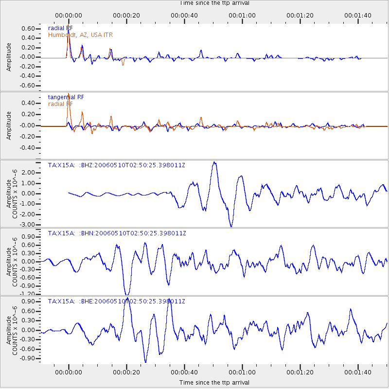
Earthquake location: Fox Islands, Aleutian Islands
Earthquake latitude/longitude: 52.5/-169.3
Earthquake time(UTC): 2006/05/10 (130) 02:42:51 GMT
Earthquake Depth: 18 km
Earthquake Magnitude: 6.1 MB, 6.2 MS, 6.4 MW, 6.3 MW
Earthquake Catalog/Contributor: WHDF/NEIC
Network: TA USArray Transportable Network (new EarthScope stations)
Station: X15A Humboldt, AZ, USA
Lat/Lon: 34.49 N/112.24 W
Elevation: 1332 m
Distance: 43.9 deg
Az: 90.948 deg
Baz: 312.291 deg
Ray Param: 0.07224996
Estimated Moho Depth: 26.0 km
Estimated Crust Vp/Vs: 2.09
Assumed Crust Vp: 6.276 km/s
Estimated Crust Vs: 2.999 km/s
Estimated Crust Poisson's Ratio: 0.35
Radial Match: 88.515366 %
Radial Bump: 308
Transverse Match: 65.86117 %
Transverse Bump: 400
SOD ConfigId: 2669
Insert Time: 2010-03-06 06:41:12.313 +0000
GWidth: 2.5
Max Bumps: 400
Tol: 0.001

Signal To Noise

ChannelStoNSTALTA
TA:X15A: :BHN:20060510T02:50:25.398011Z2.36876682.0548224E-78.674651E-8
TA:X15A: :BHE:20060510T02:50:25.398011Z1.42009391.4004928E-79.861973E-8
TA:X15A: :BHZ:20060510T02:50:25.398011Z1.24975661.357109E-71.0858988E-7
Arrivals
Ps4.8 SECOND
PpPs12 SECOND
PsPs/PpSs17 SECOND