You are here: Home > Network List > TA - USArray Transportable Network (new EarthScope stations) Stations List
> Station X15A Humboldt, AZ, USA > Earthquake Result Viewer
X15A Humboldt, AZ, USA - Earthquake Result Viewer
| Earthquake location: |
Tonga Islands |
| Earthquake latitude/longitude: |
-19.8/-174.7 |
| Earthquake time(UTC): |
2006/05/05 (125) 06:16:20 GMT |
| Earthquake Depth: |
35 km |
| Earthquake Magnitude: |
5.6 MB, 5.8 MS, 5.9 MW, 5.8 MW |
| Earthquake Catalog/Contributor: |
WHDF/NEIC |
|
| Network: |
TA USArray Transportable Network (new EarthScope stations) |
| Station: |
X15A Humboldt, AZ, USA |
| Lat/Lon: |
34.49 N/112.24 W |
| Elevation: |
1332 m |
|
| Distance: |
80.2 deg |
| Az: |
47.983 deg |
| Baz: |
237.857 deg |
| Ray Param: |
0.04838173 |
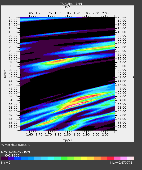
| Estimated Moho Depth: |
56.25 km |
| Estimated Crust Vp/Vs: |
1.89 |
| Assumed Crust Vp: |
6.276 km/s |
| Estimated Crust Vs: |
3.316 km/s |
| Estimated Crust Poisson's Ratio: |
0.31 |
|
| Radial Match: |
85.84492 % |
| Radial Bump: |
400 |
| Transverse Match: |
57.798325 % |
| Transverse Bump: |
395 |
| SOD ConfigId: |
2669 |
| Insert Time: |
2010-03-06 06:41:15.569 +0000 |
| GWidth: |
2.5 |
| Max Bumps: |
400 |
| Tol: |
0.001 |
|

Signal To Noise
| Channel | StoN | STA | LTA |
| TA:X15A: :BHN:20060505T06:27:56.125022Z | 0.59401655 | 7.9134246E-8 | 1.3321892E-7 |
| TA:X15A: :BHE:20060505T06:27:56.125022Z | 1.3390646 | 1.7607834E-7 | 1.3149354E-7 |
| TA:X15A: :BHZ:20060505T06:27:56.125022Z | 2.8592463 | 5.1667325E-7 | 1.807026E-7 |
| Arrivals |
| Ps | 8.2 SECOND |
| PpPs | 25 SECOND |
| PsPs/PpSs | 33 SECOND |


