You are here: Home > Network List > TA - USArray Transportable Network (new EarthScope stations) Stations List
> Station X15A Humboldt, AZ, USA > Earthquake Result Viewer
X15A Humboldt, AZ, USA - Earthquake Result Viewer
| Earthquake location: |
Vanuatu Islands |
| Earthquake latitude/longitude: |
-15.1/167.4 |
| Earthquake time(UTC): |
2006/04/30 (120) 08:17:34 GMT |
| Earthquake Depth: |
128 km |
| Earthquake Magnitude: |
5.4 MB, 6.1 MW, 6.1 MW |
| Earthquake Catalog/Contributor: |
WHDF/NEIC |
|
| Network: |
TA USArray Transportable Network (new EarthScope stations) |
| Station: |
X15A Humboldt, AZ, USA |
| Lat/Lon: |
34.49 N/112.24 W |
| Elevation: |
1332 m |
|
| Distance: |
90.7 deg |
| Az: |
54.521 deg |
| Baz: |
252.216 deg |
| Ray Param: |
0.041630276 |
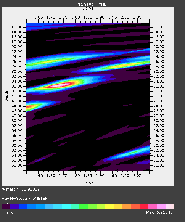
| Estimated Moho Depth: |
35.25 km |
| Estimated Crust Vp/Vs: |
1.74 |
| Assumed Crust Vp: |
6.276 km/s |
| Estimated Crust Vs: |
3.612 km/s |
| Estimated Crust Poisson's Ratio: |
0.25 |
|
| Radial Match: |
83.91089 % |
| Radial Bump: |
400 |
| Transverse Match: |
62.31383 % |
| Transverse Bump: |
357 |
| SOD ConfigId: |
2669 |
| Insert Time: |
2010-03-06 06:41:21.619 +0000 |
| GWidth: |
2.5 |
| Max Bumps: |
400 |
| Tol: |
0.001 |
|

Signal To Noise
| Channel | StoN | STA | LTA |
| TA:X15A: :BHN:20060430T08:29:51.825027Z | 1.0282943 | 6.68548E-8 | 6.5015236E-8 |
| TA:X15A: :BHE:20060430T08:29:51.825027Z | 2.1095767 | 1.3253035E-7 | 6.28232E-8 |
| TA:X15A: :BHZ:20060430T08:29:51.825027Z | 6.7509885 | 4.8061503E-7 | 7.1191806E-8 |
| Arrivals |
| Ps | 4.2 SECOND |
| PpPs | 15 SECOND |
| PsPs/PpSs | 19 SECOND |


