You are here: Home > Network List > TA - USArray Transportable Network (new EarthScope stations) Stations List
> Station X15A Humboldt, AZ, USA > Earthquake Result Viewer
X15A Humboldt, AZ, USA - Earthquake Result Viewer
| Earthquake location: |
Eastern Siberia, Russia |
| Earthquake latitude/longitude: |
61.4/167.5 |
| Earthquake time(UTC): |
2006/04/21 (111) 11:14:15 GMT |
| Earthquake Depth: |
12 km |
| Earthquake Magnitude: |
5.8 MB, 5.8 MS, 6.1 MW, 6.1 MW |
| Earthquake Catalog/Contributor: |
WHDF/NEIC |
|
| Network: |
TA USArray Transportable Network (new EarthScope stations) |
| Station: |
X15A Humboldt, AZ, USA |
| Lat/Lon: |
34.49 N/112.24 W |
| Elevation: |
1332 m |
|
| Distance: |
55.8 deg |
| Az: |
79.636 deg |
| Baz: |
324.981 deg |
| Ray Param: |
0.06452025 |
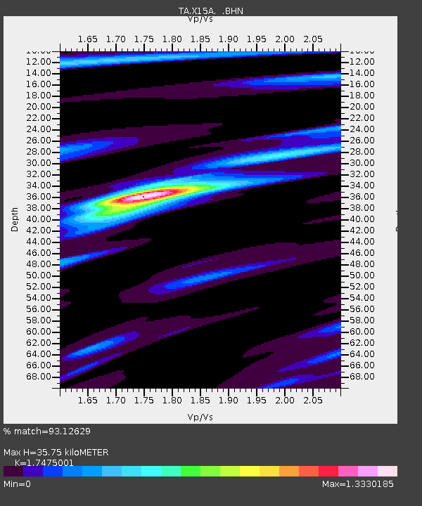
| Estimated Moho Depth: |
35.75 km |
| Estimated Crust Vp/Vs: |
1.75 |
| Assumed Crust Vp: |
6.276 km/s |
| Estimated Crust Vs: |
3.591 km/s |
| Estimated Crust Poisson's Ratio: |
0.26 |
|
| Radial Match: |
93.12629 % |
| Radial Bump: |
361 |
| Transverse Match: |
82.96696 % |
| Transverse Bump: |
400 |
| SOD ConfigId: |
2669 |
| Insert Time: |
2010-03-06 06:41:26.914 +0000 |
| GWidth: |
2.5 |
| Max Bumps: |
400 |
| Tol: |
0.001 |
|
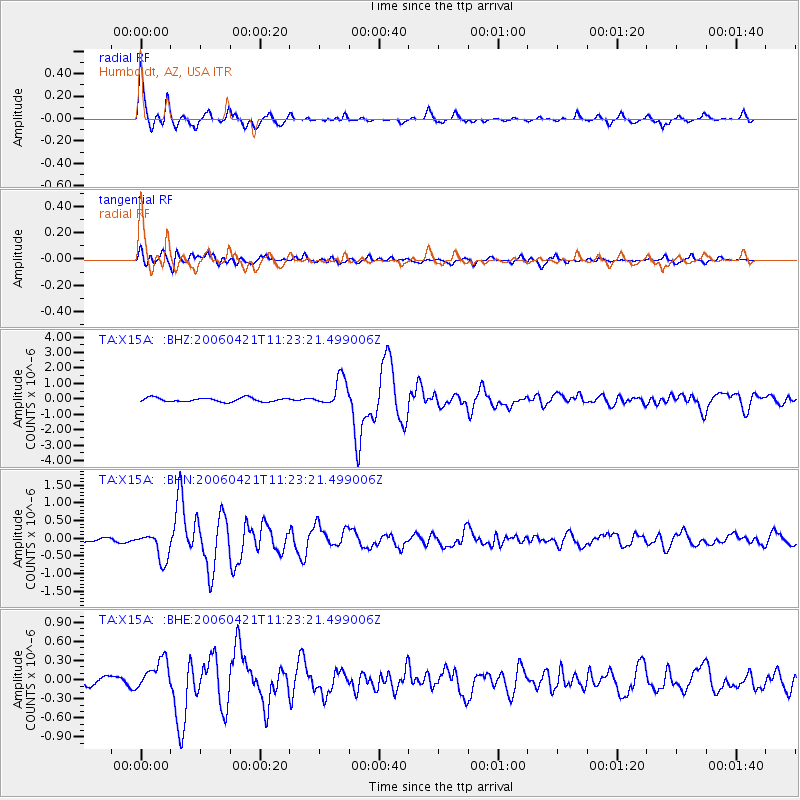
Signal To Noise
| Channel | StoN | STA | LTA |
| TA:X15A: :BHN:20060421T11:23:21.499006Z | 4.7468925 | 4.0284323E-7 | 8.4864624E-8 |
| TA:X15A: :BHE:20060421T11:23:21.499006Z | 2.0715163 | 2.3316363E-7 | 1.1255699E-7 |
| TA:X15A: :BHZ:20060421T11:23:21.499006Z | 7.126758 | 9.280175E-7 | 1.3021595E-7 |
| Arrivals |
| Ps | 4.5 SECOND |
| PpPs | 15 SECOND |
| PsPs/PpSs | 19 SECOND |


