You are here: Home > Network List > GO - National Seismic Network of Georgia Stations List
> Station AKH Akhalkalaki > Earthquake Result Viewer
AKH Akhalkalaki - Earthquake Result Viewer
| Earthquake location: |
Eastern Xizang-India Border Reg. |
| Earthquake latitude/longitude: |
29.8/95.0 |
| Earthquake time(UTC): |
2017/11/17 (321) 22:34:19 GMT |
| Earthquake Depth: |
8.0 km |
| Earthquake Magnitude: |
6.4 Mww |
| Earthquake Catalog/Contributor: |
NEIC PDE/us |
|
| Network: |
GO National Seismic Network of Georgia |
| Station: |
AKH Akhalkalaki |
| Lat/Lon: |
41.41 N/43.49 E |
| Elevation: |
1720 m |
|
| Distance: |
42.9 deg |
| Az: |
300.079 deg |
| Baz: |
88.665 deg |
| Ray Param: |
0.072913125 |
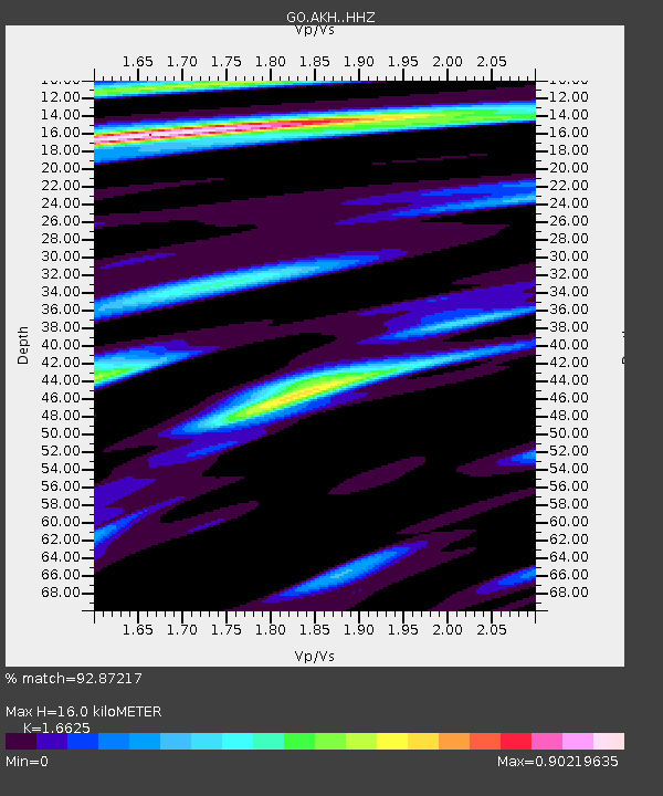
| Estimated Moho Depth: |
16.0 km |
| Estimated Crust Vp/Vs: |
1.66 |
| Assumed Crust Vp: |
6.419 km/s |
| Estimated Crust Vs: |
3.861 km/s |
| Estimated Crust Poisson's Ratio: |
0.22 |
|
| Radial Match: |
92.87217 % |
| Radial Bump: |
333 |
| Transverse Match: |
87.50416 % |
| Transverse Bump: |
320 |
| SOD ConfigId: |
13570011 |
| Insert Time: |
2019-04-29 06:23:06.899 +0000 |
| GWidth: |
2.5 |
| Max Bumps: |
400 |
| Tol: |
0.001 |
|

Signal To Noise
| Channel | StoN | STA | LTA |
| GO:AKH: :HHZ:20171117T22:41:47.120005Z | 6.768839 | 1.488808E-6 | 2.1995027E-7 |
| GO:AKH: :HHN:20171117T22:41:47.120005Z | 2.146944 | 3.244945E-7 | 1.5114249E-7 |
| GO:AKH: :HHE:20171117T22:41:47.120005Z | 2.2833693 | 9.0749785E-7 | 3.9743804E-7 |
| Arrivals |
| Ps | 1.8 SECOND |
| PpPs | 6.2 SECOND |
| PsPs/PpSs | 8.0 SECOND |


