You are here: Home > Network List > TA - USArray Transportable Network (new EarthScope stations) Stations List
> Station C26K Camden Bay, AK, USA > Earthquake Result Viewer
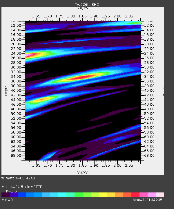
C26K Camden Bay, AK, USA - Earthquake Result Viewer
| Earthquake location: |
Eastern Xizang-India Border Reg. |
| Earthquake latitude/longitude: |
29.8/95.0 |
| Earthquake time(UTC): |
2017/11/17 (321) 22:34:19 GMT |
| Earthquake Depth: |
8.0 km |
| Earthquake Magnitude: |
6.4 Mww |
| Earthquake Catalog/Contributor: |
NEIC PDE/us |
|
| Network: |
TA USArray Transportable Network (new EarthScope stations) |
| Station: |
C26K Camden Bay, AK, USA |
| Lat/Lon: |
69.92 N/144.91 W |
| Elevation: |
139 m |
|
| Distance: |
71.7 deg |
| Az: |
18.35 deg |
| Baz: |
307.623 deg |
| Ray Param: |
0.054153427 |
| Estimated Moho Depth: |
24.5 km |
| Estimated Crust Vp/Vs: |
1.60 |
| Assumed Crust Vp: |
6.455 km/s |
| Estimated Crust Vs: |
4.035 km/s |
| Estimated Crust Poisson's Ratio: |
0.18 |
|
| Radial Match: |
88.4243 % |
| Radial Bump: |
400 |
| Transverse Match: |
81.306564 % |
| Transverse Bump: |
400 |
| SOD ConfigId: |
13570011 |
| Insert Time: |
2019-04-29 06:24:46.714 +0000 |
| GWidth: |
2.5 |
| Max Bumps: |
400 |
| Tol: |
0.001 |
|

Signal To Noise
| Channel | StoN | STA | LTA |
| TA:C26K: :BHZ:20171117T22:45:10.599985Z | 3.5329354 | 8.833402E-7 | 2.500301E-7 |
| TA:C26K: :BHN:20171117T22:45:10.599985Z | 1.3094057 | 4.999454E-7 | 3.8181093E-7 |
| TA:C26K: :BHE:20171117T22:45:10.599985Z | 0.38496703 | 2.0939078E-7 | 5.439187E-7 |
| Arrivals |
| Ps | 2.4 SECOND |
| PpPs | 9.5 SECOND |
| PsPs/PpSs | 12 SECOND |


