You are here: Home > Network List > TA - USArray Transportable Network (new EarthScope stations) Stations List
> Station D25K Kavik River, AK, USA > Earthquake Result Viewer
D25K Kavik River, AK, USA - Earthquake Result Viewer

| Earthquake location: |
Eastern Xizang-India Border Reg. |
| Earthquake latitude/longitude: |
29.8/95.0 |
| Earthquake time(UTC): |
2017/11/17 (321) 22:34:19 GMT |
| Earthquake Depth: |
8.0 km |
| Earthquake Magnitude: |
6.4 Mww |
| Earthquake Catalog/Contributor: |
NEIC PDE/us |
|
| Network: |
TA USArray Transportable Network (new EarthScope stations) |
| Station: |
D25K Kavik River, AK, USA |
| Lat/Lon: |
69.32 N/146.38 W |
| Elevation: |
770 m |
|
| Distance: |
71.7 deg |
| Az: |
19.178 deg |
| Baz: |
306.513 deg |
| Ray Param: |
0.05418562 |
| Estimated Moho Depth: |
43.0 km |
| Estimated Crust Vp/Vs: |
1.64 |
| Assumed Crust Vp: |
6.378 km/s |
| Estimated Crust Vs: |
3.889 km/s |
| Estimated Crust Poisson's Ratio: |
0.20 |
|
| Radial Match: |
87.798485 % |
| Radial Bump: |
400 |
| Transverse Match: |
87.26861 % |
| Transverse Bump: |
392 |
| SOD ConfigId: |
13570011 |
| Insert Time: |
2019-04-29 06:24:49.605 +0000 |
| GWidth: |
2.5 |
| Max Bumps: |
400 |
| Tol: |
0.001 |
|
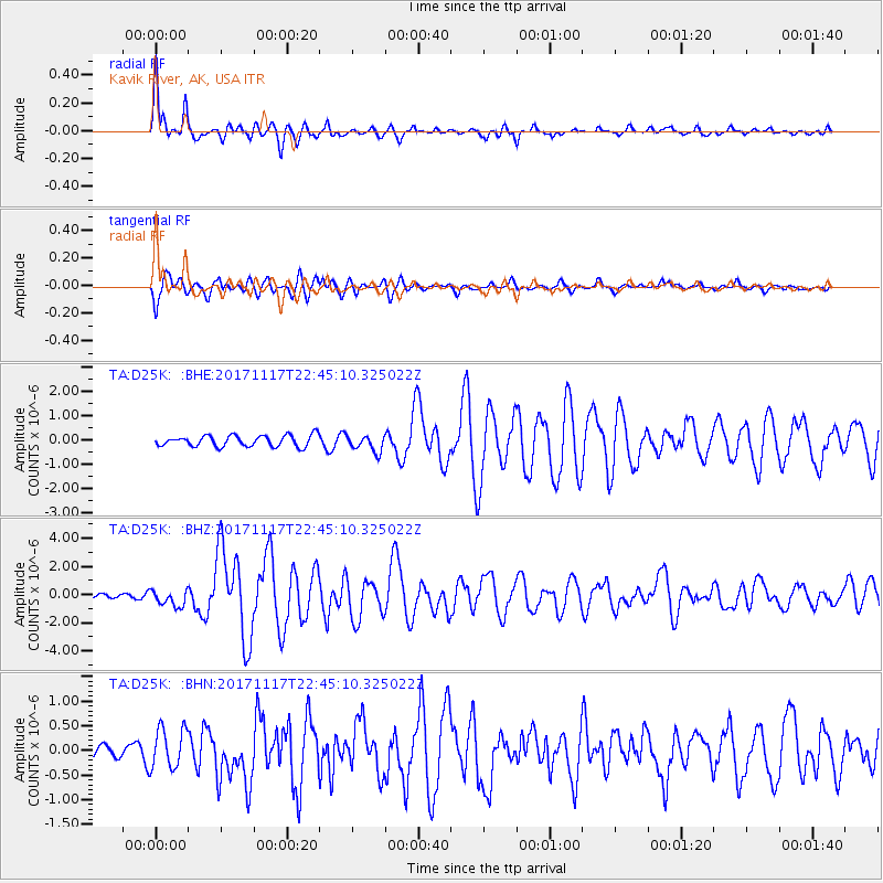
Signal To Noise
| Channel | StoN | STA | LTA |
| TA:D25K: :BHZ:20171117T22:45:10.325022Z | 3.1483126 | 5.878983E-7 | 1.8673441E-7 |
| TA:D25K: :BHN:20171117T22:45:10.325022Z | 2.2032263 | 4.0947228E-7 | 1.8585122E-7 |
| TA:D25K: :BHE:20171117T22:45:10.325022Z | 1.4595815 | 3.3346035E-7 | 2.2846298E-7 |
| Arrivals |
| Ps | 4.5 SECOND |
| PpPs | 17 SECOND |
| PsPs/PpSs | 22 SECOND |


