You are here: Home > Network List > TA - USArray Transportable Network (new EarthScope stations) Stations List
> Station F22K John River, AK, USA > Earthquake Result Viewer
F22K John River, AK, USA - Earthquake Result Viewer
| Earthquake location: |
Eastern Xizang-India Border Reg. |
| Earthquake latitude/longitude: |
29.8/95.0 |
| Earthquake time(UTC): |
2017/11/17 (321) 22:34:19 GMT |
| Earthquake Depth: |
8.0 km |
| Earthquake Magnitude: |
6.4 Mww |
| Earthquake Catalog/Contributor: |
NEIC PDE/us |
|
| Network: |
TA USArray Transportable Network (new EarthScope stations) |
| Station: |
F22K John River, AK, USA |
| Lat/Lon: |
67.51 N/152.18 W |
| Elevation: |
546 m |
|
| Distance: |
70.9 deg |
| Az: |
22.044 deg |
| Baz: |
302.04 deg |
| Ray Param: |
0.054674793 |
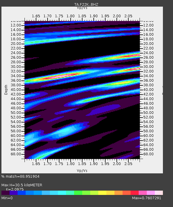
| Estimated Moho Depth: |
30.5 km |
| Estimated Crust Vp/Vs: |
2.10 |
| Assumed Crust Vp: |
6.455 km/s |
| Estimated Crust Vs: |
3.078 km/s |
| Estimated Crust Poisson's Ratio: |
0.35 |
|
| Radial Match: |
88.951904 % |
| Radial Bump: |
400 |
| Transverse Match: |
71.82168 % |
| Transverse Bump: |
400 |
| SOD ConfigId: |
13570011 |
| Insert Time: |
2019-04-29 06:25:00.644 +0000 |
| GWidth: |
2.5 |
| Max Bumps: |
400 |
| Tol: |
0.001 |
|

Signal To Noise
| Channel | StoN | STA | LTA |
| TA:F22K: :BHZ:20171117T22:45:05.799998Z | 2.3079364 | 6.3453484E-7 | 2.7493599E-7 |
| TA:F22K: :BHN:20171117T22:45:05.799998Z | 0.8632281 | 2.42625E-7 | 2.8106706E-7 |
| TA:F22K: :BHE:20171117T22:45:05.799998Z | 0.7535462 | 2.5993782E-7 | 3.4495275E-7 |
| Arrivals |
| Ps | 5.3 SECOND |
| PpPs | 14 SECOND |
| PsPs/PpSs | 20 SECOND |


