You are here: Home > Network List > TA - USArray Transportable Network (new EarthScope stations) Stations List
> Station H23K Yukon River, AK, USA > Earthquake Result Viewer
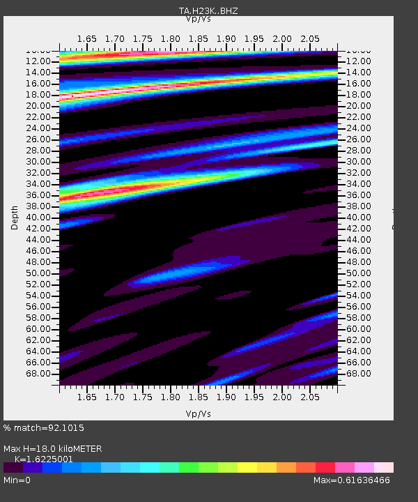
H23K Yukon River, AK, USA - Earthquake Result Viewer
| Earthquake location: |
Eastern Xizang-India Border Reg. |
| Earthquake latitude/longitude: |
29.8/95.0 |
| Earthquake time(UTC): |
2017/11/17 (321) 22:34:19 GMT |
| Earthquake Depth: |
8.0 km |
| Earthquake Magnitude: |
6.4 Mww |
| Earthquake Catalog/Contributor: |
NEIC PDE/us |
|
| Network: |
TA USArray Transportable Network (new EarthScope stations) |
| Station: |
H23K Yukon River, AK, USA |
| Lat/Lon: |
65.83 N/149.54 W |
| Elevation: |
617 m |
|
| Distance: |
72.7 deg |
| Az: |
22.921 deg |
| Baz: |
304.731 deg |
| Ray Param: |
0.053482093 |
| Estimated Moho Depth: |
18.0 km |
| Estimated Crust Vp/Vs: |
1.62 |
| Assumed Crust Vp: |
6.566 km/s |
| Estimated Crust Vs: |
4.047 km/s |
| Estimated Crust Poisson's Ratio: |
0.19 |
|
| Radial Match: |
92.1015 % |
| Radial Bump: |
396 |
| Transverse Match: |
70.17864 % |
| Transverse Bump: |
400 |
| SOD ConfigId: |
13570011 |
| Insert Time: |
2019-04-29 06:25:24.504 +0000 |
| GWidth: |
2.5 |
| Max Bumps: |
400 |
| Tol: |
0.001 |
|

Signal To Noise
| Channel | StoN | STA | LTA |
| TA:H23K: :BHZ:20171117T22:45:16.649973Z | 2.087516 | 7.027507E-7 | 3.3664446E-7 |
| TA:H23K: :BHN:20171117T22:45:16.649973Z | 0.41035572 | 1.249954E-7 | 3.0460254E-7 |
| TA:H23K: :BHE:20171117T22:45:16.649973Z | 1.295449 | 2.654964E-7 | 2.0494547E-7 |
| Arrivals |
| Ps | 1.8 SECOND |
| PpPs | 6.9 SECOND |
| PsPs/PpSs | 8.7 SECOND |


