You are here: Home > Network List > TA - USArray Transportable Network (new EarthScope stations) Stations List
> Station I17K Unalakleet, AK, USA > Earthquake Result Viewer
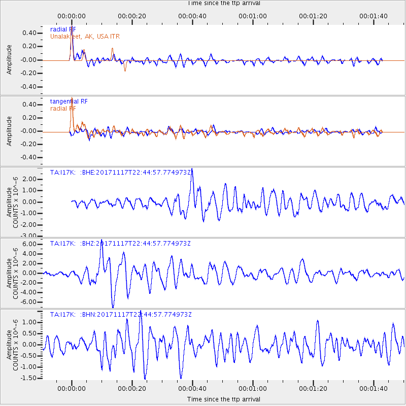
I17K Unalakleet, AK, USA - Earthquake Result Viewer
*The percent match for this event was below the threshold and hence no stack was calculated.
| Earthquake location: |
Eastern Xizang-India Border Reg. |
| Earthquake latitude/longitude: |
29.8/95.0 |
| Earthquake time(UTC): |
2017/11/17 (321) 22:34:19 GMT |
| Earthquake Depth: |
8.0 km |
| Earthquake Magnitude: |
6.4 Mww |
| Earthquake Catalog/Contributor: |
NEIC PDE/us |
|
| Network: |
TA USArray Transportable Network (new EarthScope stations) |
| Station: |
I17K Unalakleet, AK, USA |
| Lat/Lon: |
63.89 N/160.70 W |
| Elevation: |
105 m |
|
| Distance: |
69.6 deg |
| Az: |
27.23 deg |
| Baz: |
296.035 deg |
| Ray Param: |
$rayparam |
*The percent match for this event was below the threshold and hence was not used in the summary stack. |
|
| Radial Match: |
79.87611 % |
| Radial Bump: |
400 |
| Transverse Match: |
81.469124 % |
| Transverse Bump: |
400 |
| SOD ConfigId: |
13570011 |
| Insert Time: |
2019-04-29 06:25:26.972 +0000 |
| GWidth: |
2.5 |
| Max Bumps: |
400 |
| Tol: |
0.001 |
|
Signal To Noise
| Channel | StoN | STA | LTA |
| TA:I17K: :BHZ:20171117T22:44:57.774973Z | 3.8775592 | 8.4108456E-7 | 2.1691082E-7 |
| TA:I17K: :BHN:20171117T22:44:57.774973Z | 0.7439979 | 1.6791252E-7 | 2.2568952E-7 |
| TA:I17K: :BHE:20171117T22:44:57.774973Z | 1.8333199 | 4.563031E-7 | 2.4889442E-7 |
| Arrivals |
| Ps | |
| PpPs | |
| PsPs/PpSs | |


