You are here: Home > Network List > TA - USArray Transportable Network (new EarthScope stations) Stations List
> Station J18K Innoko River, AK, USA > Earthquake Result Viewer
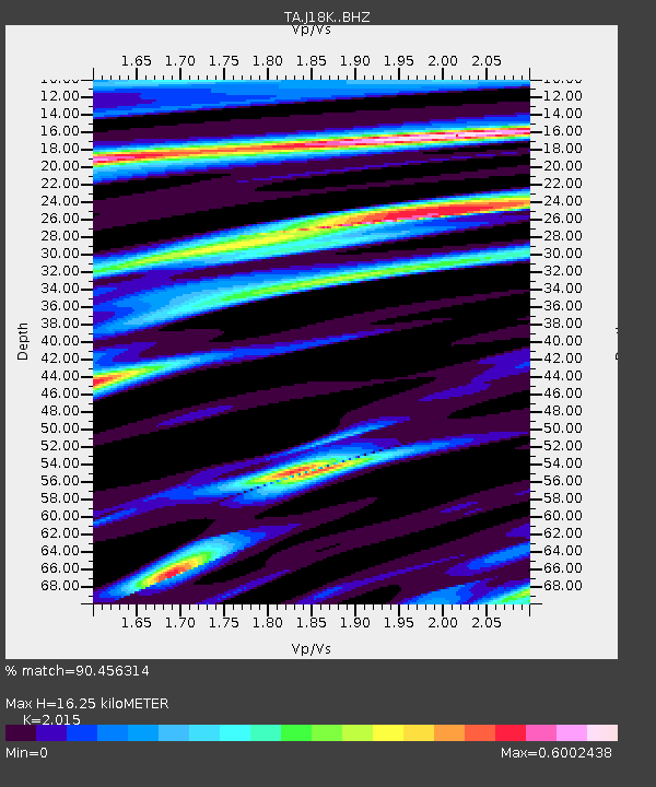
J18K Innoko River, AK, USA - Earthquake Result Viewer
| Earthquake location: |
Eastern Xizang-India Border Reg. |
| Earthquake latitude/longitude: |
29.8/95.0 |
| Earthquake time(UTC): |
2017/11/17 (321) 22:34:19 GMT |
| Earthquake Depth: |
8.0 km |
| Earthquake Magnitude: |
6.4 Mww |
| Earthquake Catalog/Contributor: |
NEIC PDE/us |
|
| Network: |
TA USArray Transportable Network (new EarthScope stations) |
| Station: |
J18K Innoko River, AK, USA |
| Lat/Lon: |
63.47 N/156.72 W |
| Elevation: |
506 m |
|
| Distance: |
71.4 deg |
| Az: |
26.751 deg |
| Baz: |
299.437 deg |
| Ray Param: |
0.054387033 |
| Estimated Moho Depth: |
16.25 km |
| Estimated Crust Vp/Vs: |
2.02 |
| Assumed Crust Vp: |
6.182 km/s |
| Estimated Crust Vs: |
3.068 km/s |
| Estimated Crust Poisson's Ratio: |
0.34 |
|
| Radial Match: |
90.456314 % |
| Radial Bump: |
400 |
| Transverse Match: |
72.33246 % |
| Transverse Bump: |
400 |
| SOD ConfigId: |
13570011 |
| Insert Time: |
2019-04-29 06:25:31.876 +0000 |
| GWidth: |
2.5 |
| Max Bumps: |
400 |
| Tol: |
0.001 |
|

Signal To Noise
| Channel | StoN | STA | LTA |
| TA:J18K: :BHZ:20171117T22:45:08.524973Z | 4.1798325 | 6.065322E-7 | 1.4510921E-7 |
| TA:J18K: :BHN:20171117T22:45:08.524973Z | 0.6537074 | 1.1236398E-7 | 1.7188727E-7 |
| TA:J18K: :BHE:20171117T22:45:08.524973Z | 1.9661585 | 3.728087E-7 | 1.8961273E-7 |
| Arrivals |
| Ps | 2.7 SECOND |
| PpPs | 7.7 SECOND |
| PsPs/PpSs | 10 SECOND |


