You are here: Home > Network List > UW - Pacific Northwest Regional Seismic Network Stations List
> Station MRBL Marblemount, WA, USA > Earthquake Result Viewer
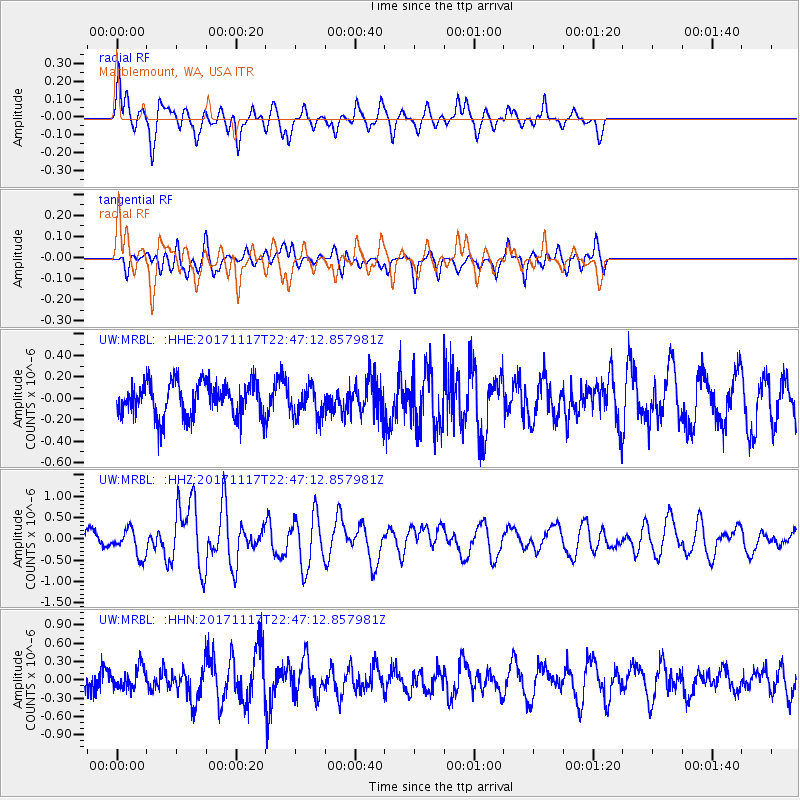
MRBL Marblemount, WA, USA - Earthquake Result Viewer
*The percent match for this event was below the threshold and hence no stack was calculated.
| Earthquake location: |
Eastern Xizang-India Border Reg. |
| Earthquake latitude/longitude: |
29.8/95.0 |
| Earthquake time(UTC): |
2017/11/17 (321) 22:34:19 GMT |
| Earthquake Depth: |
8.0 km |
| Earthquake Magnitude: |
6.4 Mww |
| Earthquake Catalog/Contributor: |
NEIC PDE/us |
|
| Network: |
UW Pacific Northwest Regional Seismic Network |
| Station: |
MRBL Marblemount, WA, USA |
| Lat/Lon: |
48.52 N/121.48 W |
| Elevation: |
75 m |
|
| Distance: |
95.4 deg |
| Az: |
23.406 deg |
| Baz: |
328.721 deg |
| Ray Param: |
$rayparam |
*The percent match for this event was below the threshold and hence was not used in the summary stack. |
|
| Radial Match: |
72.61987 % |
| Radial Bump: |
400 |
| Transverse Match: |
65.19441 % |
| Transverse Bump: |
400 |
| SOD ConfigId: |
13570011 |
| Insert Time: |
2019-04-29 06:26:15.361 +0000 |
| GWidth: |
2.5 |
| Max Bumps: |
400 |
| Tol: |
0.001 |
|
Signal To Noise
| Channel | StoN | STA | LTA |
| UW:MRBL: :HHZ:20171117T22:47:12.857981Z | 2.8323991 | 3.1238804E-7 | 1.1029096E-7 |
| UW:MRBL: :HHN:20171117T22:47:12.857981Z | 1.3423724 | 1.7204626E-7 | 1.2816582E-7 |
| UW:MRBL: :HHE:20171117T22:47:12.857981Z | 0.92284966 | 1.4588747E-7 | 1.5808368E-7 |
| Arrivals |
| Ps | |
| PpPs | |
| PsPs/PpSs | |


