You are here: Home > Network List > WY - Yellowstone Wyoming Seismic Network Stations List
> Station YHH Holmes Hill, YNP, WY, USA > Earthquake Result Viewer
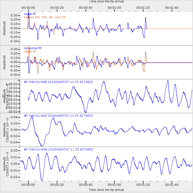
YHH Holmes Hill, YNP, WY, USA - Earthquake Result Viewer
*The percent match for this event was below the threshold and hence no stack was calculated.
| Earthquake location: |
Vanuatu Islands |
| Earthquake latitude/longitude: |
-14.1/166.6 |
| Earthquake time(UTC): |
2016/04/06 (097) 06:58:48 GMT |
| Earthquake Depth: |
24 km |
| Earthquake Magnitude: |
6.7 MWW, 6.6 MWB, 6.7 MWC, 6.9 MI |
| Earthquake Catalog/Contributor: |
NEIC PDE/NEIC COMCAT |
|
| Network: |
WY Yellowstone Wyoming Seismic Network |
| Station: |
YHH Holmes Hill, YNP, WY, USA |
| Lat/Lon: |
44.79 N/110.85 W |
| Elevation: |
2717 m |
|
| Distance: |
94.6 deg |
| Az: |
45.101 deg |
| Baz: |
254.851 deg |
| Ray Param: |
$rayparam |
*The percent match for this event was below the threshold and hence was not used in the summary stack. |
|
| Radial Match: |
66.17379 % |
| Radial Bump: |
400 |
| Transverse Match: |
54.499336 % |
| Transverse Bump: |
400 |
| SOD ConfigId: |
1475611 |
| Insert Time: |
2016-04-20 07:27:15.077 +0000 |
| GWidth: |
2.5 |
| Max Bumps: |
400 |
| Tol: |
0.001 |
|
Signal To Noise
| Channel | StoN | STA | LTA |
| WY:YHH:01:HHZ:20160406T07:11:35.827983Z | 6.772541 | 2.7058539E-8 | 3.9953303E-9 |
| WY:YHH:01:HHN:20160406T07:11:35.827983Z | 2.0130618 | 6.685023E-9 | 3.3208238E-9 |
| WY:YHH:01:HHE:20160406T07:11:35.827983Z | 2.1681268 | 7.8957765E-9 | 3.6417502E-9 |
| Arrivals |
| Ps | |
| PpPs | |
| PsPs/PpSs | |


