You are here: Home > Network List > TA - USArray Transportable Network (new EarthScope stations) Stations List
> Station Q12A Willow Creek Ranch, Ely, NV, USA > Earthquake Result Viewer
Q12A Willow Creek Ranch, Ely, NV, USA - Earthquake Result Viewer
| Earthquake location: |
Peru-Ecuador Border Region |
| Earthquake latitude/longitude: |
-2.3/-77.8 |
| Earthquake time(UTC): |
2007/11/16 (320) 03:13:00 GMT |
| Earthquake Depth: |
123 km |
| Earthquake Magnitude: |
6.3 MB, 6.8 MW, 6.7 MW |
| Earthquake Catalog/Contributor: |
WHDF/NEIC |
|
| Network: |
TA USArray Transportable Network (new EarthScope stations) |
| Station: |
Q12A Willow Creek Ranch, Ely, NV, USA |
| Lat/Lon: |
39.04 N/114.83 W |
| Elevation: |
1625 m |
|
| Distance: |
53.4 deg |
| Az: |
324.284 deg |
| Baz: |
131.497 deg |
| Ray Param: |
0.065724656 |
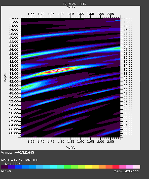
| Estimated Moho Depth: |
36.25 km |
| Estimated Crust Vp/Vs: |
1.78 |
| Assumed Crust Vp: |
6.276 km/s |
| Estimated Crust Vs: |
3.521 km/s |
| Estimated Crust Poisson's Ratio: |
0.27 |
|
| Radial Match: |
90.521645 % |
| Radial Bump: |
400 |
| Transverse Match: |
81.20131 % |
| Transverse Bump: |
400 |
| SOD ConfigId: |
2564 |
| Insert Time: |
2010-03-06 06:43:32.742 +0000 |
| GWidth: |
2.5 |
| Max Bumps: |
400 |
| Tol: |
0.001 |
|
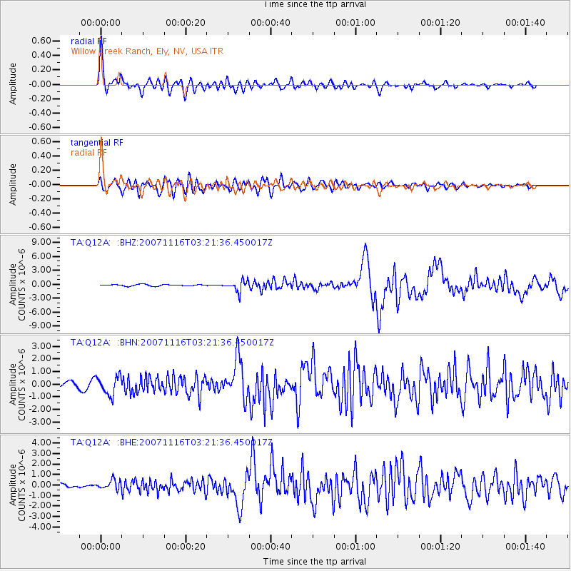
Signal To Noise
| Channel | StoN | STA | LTA |
| TA:Q12A: :BHN:20071116T03:21:36.450017Z | 3.3410985 | 7.355694E-7 | 2.2015796E-7 |
| TA:Q12A: :BHE:20071116T03:21:36.450017Z | 2.206247 | 4.4195005E-7 | 2.0031757E-7 |
| TA:Q12A: :BHZ:20071116T03:21:36.450017Z | 7.1398497 | 1.1685959E-6 | 1.6367234E-7 |
| Arrivals |
| Ps | 4.8 SECOND |
| PpPs | 15 SECOND |
| PsPs/PpSs | 20 SECOND |


