You are here: Home > Network List > TA - USArray Transportable Network (new EarthScope stations) Stations List
> Station Q12A Willow Creek Ranch, Ely, NV, USA > Earthquake Result Viewer
Q12A Willow Creek Ranch, Ely, NV, USA - Earthquake Result Viewer
| Earthquake location: |
Vanuatu Islands |
| Earthquake latitude/longitude: |
-15.6/167.7 |
| Earthquake time(UTC): |
2007/08/01 (213) 17:08:51 GMT |
| Earthquake Depth: |
120 km |
| Earthquake Magnitude: |
6.2 MB, 7.2 MW, 7.2 MW |
| Earthquake Catalog/Contributor: |
WHDF/NEIC |
|
| Network: |
TA USArray Transportable Network (new EarthScope stations) |
| Station: |
Q12A Willow Creek Ranch, Ely, NV, USA |
| Lat/Lon: |
39.04 N/114.83 W |
| Elevation: |
1625 m |
|
| Distance: |
90.3 deg |
| Az: |
49.49 deg |
| Baz: |
250.184 deg |
| Ray Param: |
0.04165978 |
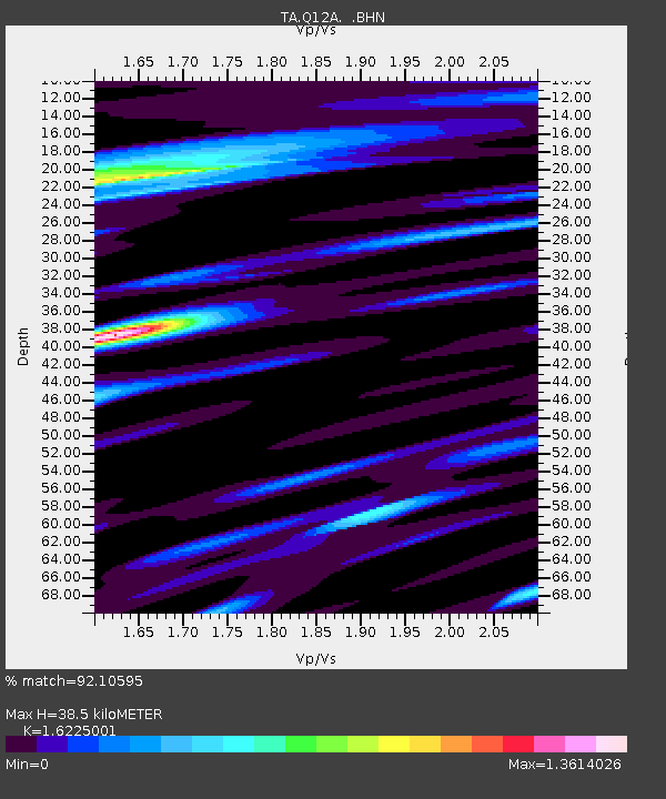
| Estimated Moho Depth: |
38.5 km |
| Estimated Crust Vp/Vs: |
1.62 |
| Assumed Crust Vp: |
6.276 km/s |
| Estimated Crust Vs: |
3.868 km/s |
| Estimated Crust Poisson's Ratio: |
0.19 |
|
| Radial Match: |
92.10595 % |
| Radial Bump: |
400 |
| Transverse Match: |
86.442184 % |
| Transverse Bump: |
400 |
| SOD ConfigId: |
2564 |
| Insert Time: |
2010-03-06 06:44:11.351 +0000 |
| GWidth: |
2.5 |
| Max Bumps: |
400 |
| Tol: |
0.001 |
|

Signal To Noise
| Channel | StoN | STA | LTA |
| TA:Q12A: :BHN:20070801T17:21:07.475012Z | 1.1334485 | 6.521079E-8 | 5.7533086E-8 |
| TA:Q12A: :BHE:20070801T17:21:07.475012Z | 1.7952048 | 1.2480456E-7 | 6.952107E-8 |
| TA:Q12A: :BHZ:20070801T17:21:07.475012Z | 4.4366302 | 4.574105E-7 | 1.0309863E-7 |
| Arrivals |
| Ps | 3.9 SECOND |
| PpPs | 16 SECOND |
| PsPs/PpSs | 20 SECOND |


