You are here: Home > Network List > TA - USArray Transportable Network (new EarthScope stations) Stations List
> Station D23K Nanushuk River, AK USA > Earthquake Result Viewer
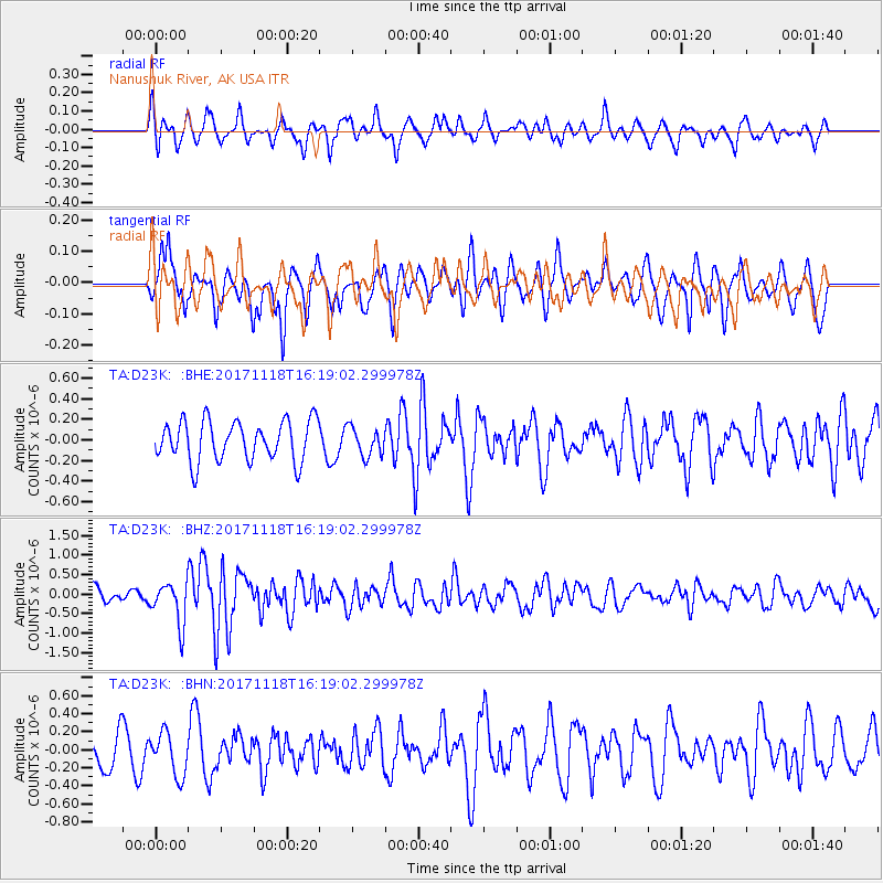
D23K Nanushuk River, AK USA - Earthquake Result Viewer
*The percent match for this event was below the threshold and hence no stack was calculated.
| Earthquake location: |
Halmahera, Indonesia |
| Earthquake latitude/longitude: |
2.4/128.1 |
| Earthquake time(UTC): |
2017/11/18 (322) 16:07:02 GMT |
| Earthquake Depth: |
20 km |
| Earthquake Magnitude: |
5.9 Mww |
| Earthquake Catalog/Contributor: |
NEIC PDE/us |
|
| Network: |
TA USArray Transportable Network (new EarthScope stations) |
| Station: |
D23K Nanushuk River, AK USA |
| Lat/Lon: |
68.97 N/150.68 W |
| Elevation: |
406 m |
|
| Distance: |
84.6 deg |
| Az: |
20.998 deg |
| Baz: |
262.611 deg |
| Ray Param: |
$rayparam |
*The percent match for this event was below the threshold and hence was not used in the summary stack. |
|
| Radial Match: |
62.213215 % |
| Radial Bump: |
362 |
| Transverse Match: |
60.79469 % |
| Transverse Bump: |
346 |
| SOD ConfigId: |
13570011 |
| Insert Time: |
2019-04-29 06:37:16.338 +0000 |
| GWidth: |
2.5 |
| Max Bumps: |
400 |
| Tol: |
0.001 |
|
Signal To Noise
| Channel | StoN | STA | LTA |
| TA:D23K: :BHZ:20171118T16:19:02.299978Z | 2.17074 | 5.319487E-7 | 2.4505408E-7 |
| TA:D23K: :BHN:20171118T16:19:02.299978Z | 1.149227 | 2.3620427E-7 | 2.0553318E-7 |
| TA:D23K: :BHE:20171118T16:19:02.299978Z | 0.70511127 | 1.3747571E-7 | 1.9497023E-7 |
| Arrivals |
| Ps | |
| PpPs | |
| PsPs/PpSs | |


