You are here: Home > Network List > TA - USArray Transportable Network (new EarthScope stations) Stations List
> Station G21K Allakaket, AK, USA > Earthquake Result Viewer
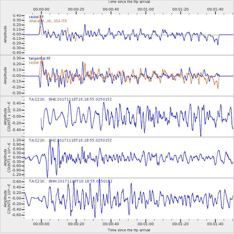
G21K Allakaket, AK, USA - Earthquake Result Viewer
*The percent match for this event was below the threshold and hence no stack was calculated.
| Earthquake location: |
Halmahera, Indonesia |
| Earthquake latitude/longitude: |
2.4/128.1 |
| Earthquake time(UTC): |
2017/11/18 (322) 16:07:02 GMT |
| Earthquake Depth: |
20 km |
| Earthquake Magnitude: |
5.9 Mww |
| Earthquake Catalog/Contributor: |
NEIC PDE/us |
|
| Network: |
TA USArray Transportable Network (new EarthScope stations) |
| Station: |
G21K Allakaket, AK, USA |
| Lat/Lon: |
66.52 N/153.51 W |
| Elevation: |
446 m |
|
| Distance: |
83.2 deg |
| Az: |
23.284 deg |
| Baz: |
260.241 deg |
| Ray Param: |
$rayparam |
*The percent match for this event was below the threshold and hence was not used in the summary stack. |
|
| Radial Match: |
55.66197 % |
| Radial Bump: |
400 |
| Transverse Match: |
62.573574 % |
| Transverse Bump: |
400 |
| SOD ConfigId: |
13570011 |
| Insert Time: |
2019-04-29 06:37:28.549 +0000 |
| GWidth: |
2.5 |
| Max Bumps: |
400 |
| Tol: |
0.001 |
|
Signal To Noise
| Channel | StoN | STA | LTA |
| TA:G21K: :BHZ:20171118T16:18:55.025015Z | 4.169088 | 5.3827694E-7 | 1.2911144E-7 |
| TA:G21K: :BHN:20171118T16:18:55.025015Z | 1.0780181 | 1.7609455E-7 | 1.6335026E-7 |
| TA:G21K: :BHE:20171118T16:18:55.025015Z | 1.0419642 | 1.9639573E-7 | 1.8848607E-7 |
| Arrivals |
| Ps | |
| PpPs | |
| PsPs/PpSs | |


