You are here: Home > Network List > TA - USArray Transportable Network (new EarthScope stations) Stations List
> Station Q12A Willow Creek Ranch, Ely, NV, USA > Earthquake Result Viewer
Q12A Willow Creek Ranch, Ely, NV, USA - Earthquake Result Viewer
| Earthquake location: |
Solomon Islands |
| Earthquake latitude/longitude: |
-8.5/157.0 |
| Earthquake time(UTC): |
2007/04/01 (091) 20:39:56 GMT |
| Earthquake Depth: |
10 km |
| Earthquake Magnitude: |
6.8 MB, 7.9 MS, 8.1 MW, 7.7 ME |
| Earthquake Catalog/Contributor: |
WHDF/NEIC |
|
| Network: |
TA USArray Transportable Network (new EarthScope stations) |
| Station: |
Q12A Willow Creek Ranch, Ely, NV, USA |
| Lat/Lon: |
39.04 N/114.83 W |
| Elevation: |
1625 m |
|
| Distance: |
93.8 deg |
| Az: |
51.268 deg |
| Baz: |
262.275 deg |
| Ray Param: |
0.04118666 |
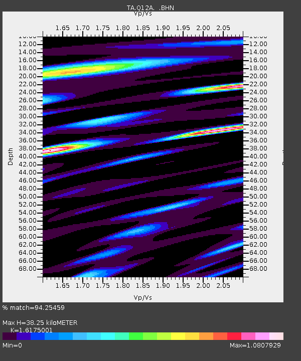
| Estimated Moho Depth: |
38.25 km |
| Estimated Crust Vp/Vs: |
1.62 |
| Assumed Crust Vp: |
6.276 km/s |
| Estimated Crust Vs: |
3.88 km/s |
| Estimated Crust Poisson's Ratio: |
0.19 |
|
| Radial Match: |
94.25459 % |
| Radial Bump: |
400 |
| Transverse Match: |
89.57936 % |
| Transverse Bump: |
400 |
| SOD ConfigId: |
2564 |
| Insert Time: |
2010-03-06 06:44:39.125 +0000 |
| GWidth: |
2.5 |
| Max Bumps: |
400 |
| Tol: |
0.001 |
|
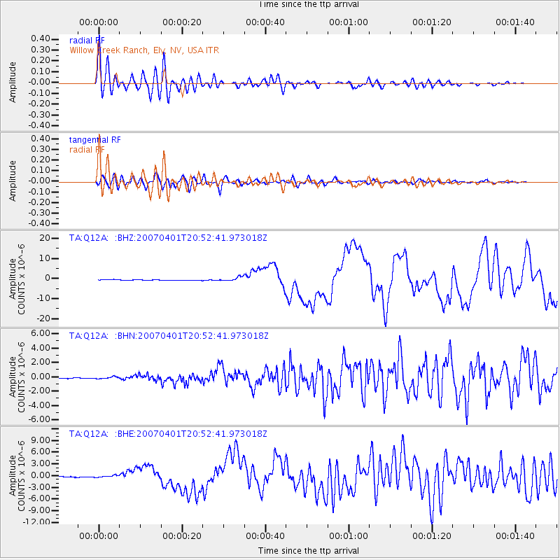
Signal To Noise
| Channel | StoN | STA | LTA |
| TA:Q12A: :BHN:20070401T20:52:41.973018Z | 1.6100354 | 1.4021897E-7 | 8.709061E-8 |
| TA:Q12A: :BHE:20070401T20:52:41.973018Z | 1.5547051 | 2.500753E-7 | 1.6085062E-7 |
| TA:Q12A: :BHZ:20070401T20:52:41.973018Z | 6.991167 | 1.0756107E-6 | 1.5385281E-7 |
| Arrivals |
| Ps | 3.8 SECOND |
| PpPs | 16 SECOND |
| PsPs/PpSs | 19 SECOND |


