You are here: Home > Network List > TA - USArray Transportable Network (new EarthScope stations) Stations List
> Station Q12A Willow Creek Ranch, Ely, NV, USA > Earthquake Result Viewer
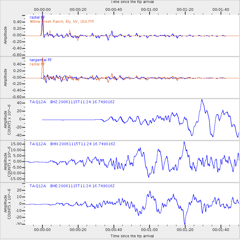
Q12A Willow Creek Ranch, Ely, NV, USA - Earthquake Result Viewer
| Earthquake location: |
Kuril Islands |
| Earthquake latitude/longitude: |
46.6/153.3 |
| Earthquake time(UTC): |
2006/11/15 (319) 11:14:13 GMT |
| Earthquake Depth: |
10 km |
| Earthquake Magnitude: |
6.5 MB, 7.8 MS, 8.3 MW, 7.9 MW |
| Earthquake Catalog/Contributor: |
WHDF/NEIC |
|
| Network: |
TA USArray Transportable Network (new EarthScope stations) |
| Station: |
Q12A Willow Creek Ranch, Ely, NV, USA |
| Lat/Lon: |
39.04 N/114.83 W |
| Elevation: |
1625 m |
|
| Distance: |
64.1 deg |
| Az: |
59.891 deg |
| Baz: |
310.0 deg |
| Ray Param: |
0.059126418 |
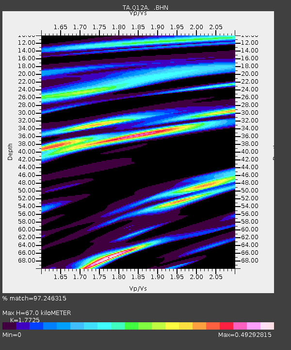
| Estimated Moho Depth: |
67.0 km |
| Estimated Crust Vp/Vs: |
1.77 |
| Assumed Crust Vp: |
6.276 km/s |
| Estimated Crust Vs: |
3.541 km/s |
| Estimated Crust Poisson's Ratio: |
0.27 |
|
| Radial Match: |
97.246315 % |
| Radial Bump: |
400 |
| Transverse Match: |
81.03339 % |
| Transverse Bump: |
400 |
| SOD ConfigId: |
2564 |
| Insert Time: |
2010-03-06 06:44:46.180 +0000 |
| GWidth: |
2.5 |
| Max Bumps: |
400 |
| Tol: |
0.001 |
|
Signal To Noise
| Channel | StoN | STA | LTA |
| TA:Q12A: :BHN:20061115T11:24:16.749016Z | 1.4458394 | 3.5092035E-7 | 2.4271046E-7 |
| TA:Q12A: :BHE:20061115T11:24:16.749016Z | 2.1258435 | 4.3343096E-7 | 2.0388657E-7 |
| TA:Q12A: :BHZ:20061115T11:24:16.749016Z | 7.4526114 | 1.5192503E-6 | 2.0385475E-7 |
| Arrivals |
| Ps | 8.6 SECOND |
| PpPs | 28 SECOND |
| PsPs/PpSs | 37 SECOND |


