You are here: Home > Network List > TA - USArray Transportable Network (new EarthScope stations) Stations List
> Station Q12A Willow Creek Ranch, Ely, NV, USA > Earthquake Result Viewer
Q12A Willow Creek Ranch, Ely, NV, USA - Earthquake Result Viewer
| Earthquake location: |
New Britain Region, P.N.G. |
| Earthquake latitude/longitude: |
-5.9/151.0 |
| Earthquake time(UTC): |
2006/10/17 (290) 01:25:12 GMT |
| Earthquake Depth: |
32 km |
| Earthquake Magnitude: |
6.4 MB, 6.9 MS, 6.7 MW, 6.6 MW |
| Earthquake Catalog/Contributor: |
WHDF/NEIC |
|
| Network: |
TA USArray Transportable Network (new EarthScope stations) |
| Station: |
Q12A Willow Creek Ranch, Ely, NV, USA |
| Lat/Lon: |
39.04 N/114.83 W |
| Elevation: |
1625 m |
|
| Distance: |
96.9 deg |
| Az: |
51.479 deg |
| Baz: |
268.055 deg |
| Ray Param: |
0.04035593 |
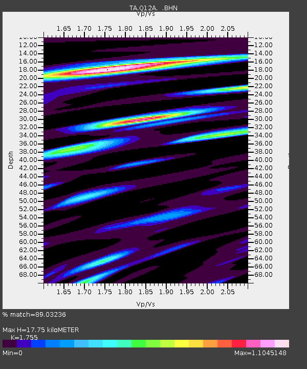
| Estimated Moho Depth: |
17.75 km |
| Estimated Crust Vp/Vs: |
1.75 |
| Assumed Crust Vp: |
6.276 km/s |
| Estimated Crust Vs: |
3.576 km/s |
| Estimated Crust Poisson's Ratio: |
0.26 |
|
| Radial Match: |
89.03236 % |
| Radial Bump: |
400 |
| Transverse Match: |
81.793816 % |
| Transverse Bump: |
400 |
| SOD ConfigId: |
2564 |
| Insert Time: |
2010-03-06 06:44:50.105 +0000 |
| GWidth: |
2.5 |
| Max Bumps: |
400 |
| Tol: |
0.001 |
|

Signal To Noise
| Channel | StoN | STA | LTA |
| TA:Q12A: :BHN:20061017T01:38:08.823018Z | 0.6024508 | 8.094506E-8 | 1.3435962E-7 |
| TA:Q12A: :BHE:20061017T01:38:08.823018Z | 4.653107 | 4.504816E-7 | 9.681307E-8 |
| TA:Q12A: :BHZ:20061017T01:38:08.823018Z | 10.378838 | 1.6998432E-6 | 1.6377973E-7 |
| Arrivals |
| Ps | 2.2 SECOND |
| PpPs | 7.6 SECOND |
| PsPs/PpSs | 9.8 SECOND |


