You are here: Home > Network List > TA - USArray Transportable Network (new EarthScope stations) Stations List
> Station F26K Sheenjek River, AK, USA > Earthquake Result Viewer
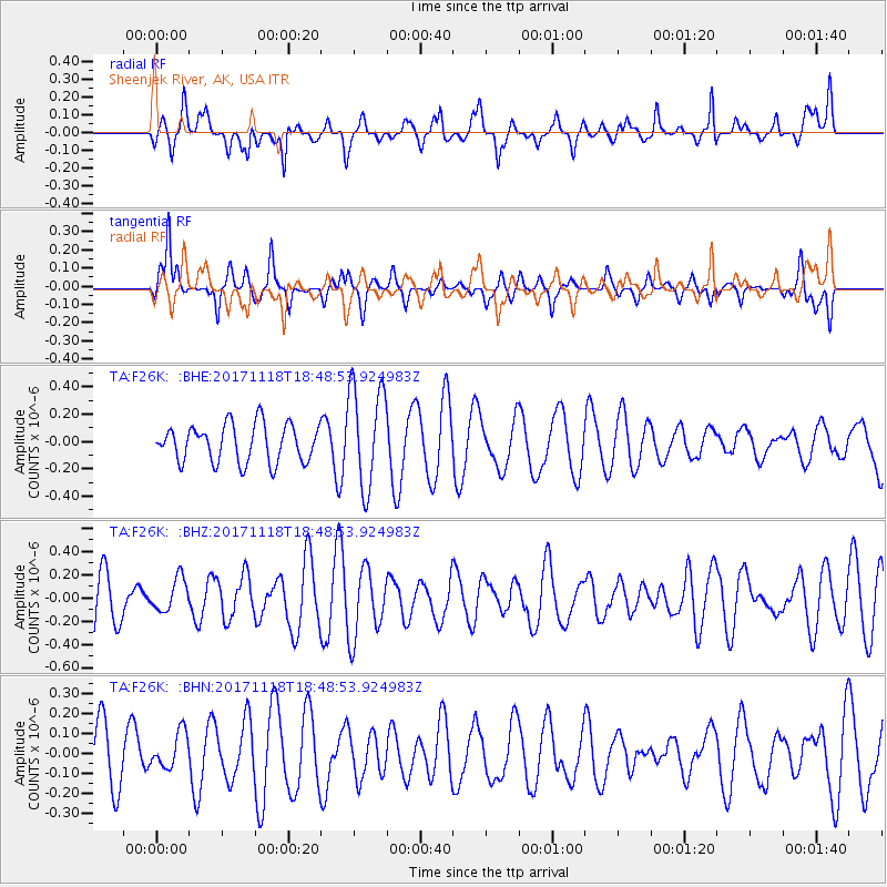
F26K Sheenjek River, AK, USA - Earthquake Result Viewer
*The percent match for this event was below the threshold and hence no stack was calculated.
| Earthquake location: |
Halmahera, Indonesia |
| Earthquake latitude/longitude: |
2.4/128.1 |
| Earthquake time(UTC): |
2017/11/18 (322) 18:36:41 GMT |
| Earthquake Depth: |
17 km |
| Earthquake Magnitude: |
5.4 Mww |
| Earthquake Catalog/Contributor: |
NEIC PDE/us |
|
| Network: |
TA USArray Transportable Network (new EarthScope stations) |
| Station: |
F26K Sheenjek River, AK, USA |
| Lat/Lon: |
67.69 N/144.15 W |
| Elevation: |
683 m |
|
| Distance: |
86.9 deg |
| Az: |
22.456 deg |
| Baz: |
268.791 deg |
| Ray Param: |
$rayparam |
*The percent match for this event was below the threshold and hence was not used in the summary stack. |
|
| Radial Match: |
43.82724 % |
| Radial Bump: |
400 |
| Transverse Match: |
60.183285 % |
| Transverse Bump: |
387 |
| SOD ConfigId: |
13570011 |
| Insert Time: |
2019-04-29 06:40:26.245 +0000 |
| GWidth: |
2.5 |
| Max Bumps: |
400 |
| Tol: |
0.001 |
|
Signal To Noise
| Channel | StoN | STA | LTA |
| TA:F26K: :BHZ:20171118T18:48:53.924983Z | 0.7437515 | 1.4046653E-7 | 1.8886216E-7 |
| TA:F26K: :BHN:20171118T18:48:53.924983Z | 0.4267567 | 8.984104E-8 | 2.105205E-7 |
| TA:F26K: :BHE:20171118T18:48:53.924983Z | 2.6988158 | 3.744952E-7 | 1.3876279E-7 |
| Arrivals |
| Ps | |
| PpPs | |
| PsPs/PpSs | |


